You are here: Home > Network List > AV - Alaska Volcano Observatory Stations List
> Station VNKR Kametolook River, Mount Veniaminof, Alaska > Earthquake Result Viewer
VNKR Kametolook River, Mount Veniaminof, Alaska - Earthquake Result Viewer
| Earthquake location: |
South Of Kermadec Islands |
| Earthquake latitude/longitude: |
-32.7/-179.3 |
| Earthquake time(UTC): |
2023/09/08 (251) 09:09:58 GMT |
| Earthquake Depth: |
90 km |
| Earthquake Magnitude: |
6.6 mww |
| Earthquake Catalog/Contributor: |
NEIC PDE/us |
|
| Network: |
AV Alaska Volcano Observatory |
| Station: |
VNKR Kametolook River, Mount Veniaminof, Alaska |
| Lat/Lon: |
56.03 N/159.37 W |
| Elevation: |
620 m |
|
| Distance: |
90.0 deg |
| Az: |
11.035 deg |
| Baz: |
196.704 deg |
| Ray Param: |
0.041714188 |
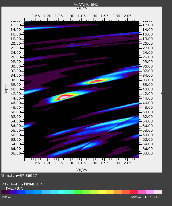
| Estimated Moho Depth: |
43.5 km |
| Estimated Crust Vp/Vs: |
1.77 |
| Assumed Crust Vp: |
6.134 km/s |
| Estimated Crust Vs: |
3.47 km/s |
| Estimated Crust Poisson's Ratio: |
0.26 |
|
| Radial Match: |
87.86907 % |
| Radial Bump: |
400 |
| Transverse Match: |
86.230515 % |
| Transverse Bump: |
400 |
| SOD ConfigId: |
31937991 |
| Insert Time: |
2023-09-22 09:36:32.150 +0000 |
| GWidth: |
2.5 |
| Max Bumps: |
400 |
| Tol: |
0.001 |
|

Signal To Noise
| Channel | StoN | STA | LTA |
| AV:VNKR: :BHZ:20230908T09:22:16.899024Z | 14.223029 | 4.919433E-6 | 3.45878E-7 |
| AV:VNKR: :BHN:20230908T09:22:16.899024Z | 3.2704594 | 1.983644E-6 | 6.065338E-7 |
| AV:VNKR: :BHE:20230908T09:22:16.899024Z | 1.5782208 | 9.937166E-7 | 6.2964364E-7 |
| Arrivals |
| Ps | 5.5 SECOND |
| PpPs | 19 SECOND |
| PsPs/PpSs | 25 SECOND |


