You are here: Home > Network List > AZ - ANZA Regional Network Stations List
> Station RRSP RRSP, CA, USA > Earthquake Result Viewer
RRSP RRSP, CA, USA - Earthquake Result Viewer
| Earthquake location: |
South Of Kermadec Islands |
| Earthquake latitude/longitude: |
-32.7/-179.3 |
| Earthquake time(UTC): |
2023/09/08 (251) 09:09:58 GMT |
| Earthquake Depth: |
90 km |
| Earthquake Magnitude: |
6.6 mww |
| Earthquake Catalog/Contributor: |
NEIC PDE/us |
|
| Network: |
AZ ANZA Regional Network |
| Station: |
RRSP RRSP, CA, USA |
| Lat/Lon: |
33.65 N/116.74 W |
| Elevation: |
1610 m |
|
| Distance: |
88.4 deg |
| Az: |
47.784 deg |
| Baz: |
228.454 deg |
| Ray Param: |
0.042401254 |
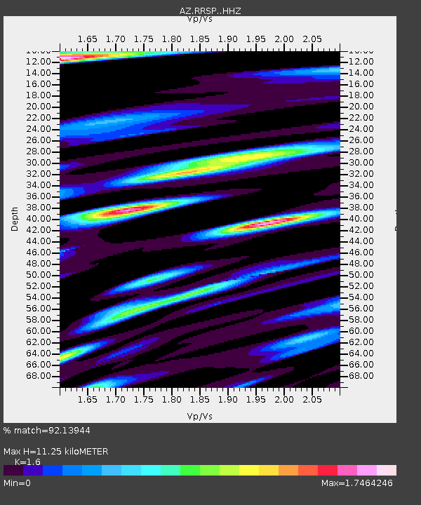
| Estimated Moho Depth: |
11.25 km |
| Estimated Crust Vp/Vs: |
1.60 |
| Assumed Crust Vp: |
6.264 km/s |
| Estimated Crust Vs: |
3.915 km/s |
| Estimated Crust Poisson's Ratio: |
0.18 |
|
| Radial Match: |
92.13944 % |
| Radial Bump: |
400 |
| Transverse Match: |
88.42524 % |
| Transverse Bump: |
400 |
| SOD ConfigId: |
31937991 |
| Insert Time: |
2023-09-22 09:37:00.744 +0000 |
| GWidth: |
2.5 |
| Max Bumps: |
400 |
| Tol: |
0.001 |
|

Signal To Noise
| Channel | StoN | STA | LTA |
| AZ:RRSP: :HHZ:20230908T09:22:09.504005Z | 25.236946 | 2.8706922E-6 | 1.1374959E-7 |
| AZ:RRSP: :HHN:20230908T09:22:09.504005Z | 3.6054316 | 4.84742E-7 | 1.344477E-7 |
| AZ:RRSP: :HHE:20230908T09:22:09.504005Z | 4.506931 | 5.0078853E-7 | 1.111152E-7 |
| Arrivals |
| Ps | 1.1 SECOND |
| PpPs | 4.6 SECOND |
| PsPs/PpSs | 5.7 SECOND |


