You are here: Home > Network List > BK - Berkeley Digital Seismograph Network Stations List
> Station MCCM Marconi Conference Center, Marshall, CA, USA > Earthquake Result Viewer
MCCM Marconi Conference Center, Marshall, CA, USA - Earthquake Result Viewer
| Earthquake location: |
South Of Kermadec Islands |
| Earthquake latitude/longitude: |
-32.7/-179.3 |
| Earthquake time(UTC): |
2023/09/08 (251) 09:09:58 GMT |
| Earthquake Depth: |
90 km |
| Earthquake Magnitude: |
6.6 mww |
| Earthquake Catalog/Contributor: |
NEIC PDE/us |
|
| Network: |
BK Berkeley Digital Seismograph Network |
| Station: |
MCCM Marconi Conference Center, Marshall, CA, USA |
| Lat/Lon: |
38.14 N/122.88 W |
| Elevation: |
-7.7 m |
|
| Distance: |
87.9 deg |
| Az: |
41.1 deg |
| Baz: |
224.65 deg |
| Ray Param: |
0.042803656 |
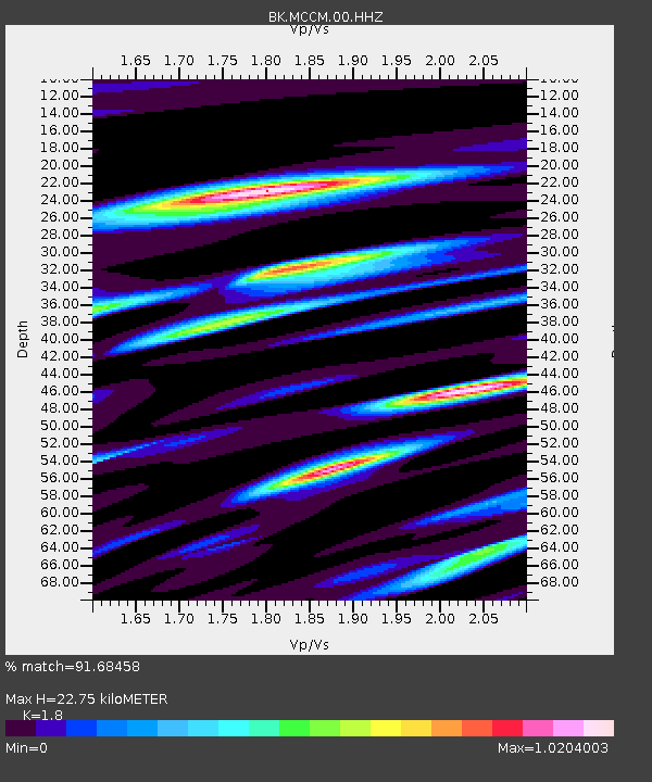
| Estimated Moho Depth: |
22.75 km |
| Estimated Crust Vp/Vs: |
1.80 |
| Assumed Crust Vp: |
6.472 km/s |
| Estimated Crust Vs: |
3.595 km/s |
| Estimated Crust Poisson's Ratio: |
0.28 |
|
| Radial Match: |
91.68458 % |
| Radial Bump: |
400 |
| Transverse Match: |
81.09327 % |
| Transverse Bump: |
400 |
| SOD ConfigId: |
31937991 |
| Insert Time: |
2023-09-22 09:37:46.545 +0000 |
| GWidth: |
2.5 |
| Max Bumps: |
400 |
| Tol: |
0.001 |
|

Signal To Noise
| Channel | StoN | STA | LTA |
| BK:MCCM:00:HHZ:20230908T09:22:06.947975Z | 8.789257 | 2.4959872E-6 | 2.839816E-7 |
| BK:MCCM:00:HHN:20230908T09:22:06.947975Z | 2.1198106 | 6.905479E-7 | 3.2575923E-7 |
| BK:MCCM:00:HHE:20230908T09:22:06.947975Z | 1.7337837 | 6.889458E-7 | 3.9736545E-7 |
| Arrivals |
| Ps | 2.9 SECOND |
| PpPs | 9.6 SECOND |
| PsPs/PpSs | 13 SECOND |


