You are here: Home > Network List > CC - Cascade Chain Volcano Monitoring Stations List
> Station HOA Hoala > Earthquake Result Viewer
HOA Hoala - Earthquake Result Viewer
| Earthquake location: |
South Of Kermadec Islands |
| Earthquake latitude/longitude: |
-32.7/-179.3 |
| Earthquake time(UTC): |
2023/09/08 (251) 09:09:58 GMT |
| Earthquake Depth: |
90 km |
| Earthquake Magnitude: |
6.6 mww |
| Earthquake Catalog/Contributor: |
NEIC PDE/us |
|
| Network: |
CC Cascade Chain Volcano Monitoring |
| Station: |
HOA Hoala |
| Lat/Lon: |
46.24 N/122.19 W |
| Elevation: |
1151 m |
|
| Distance: |
94.0 deg |
| Az: |
35.75 deg |
| Baz: |
225.201 deg |
| Ray Param: |
0.041092426 |
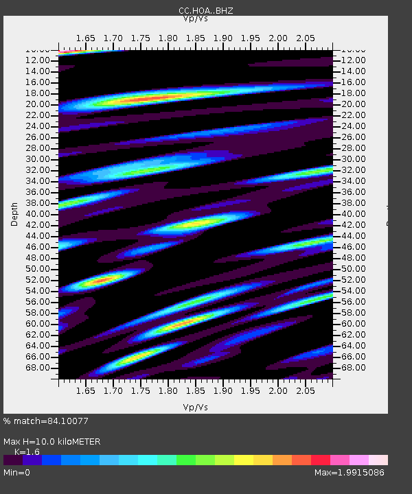
| Estimated Moho Depth: |
10.0 km |
| Estimated Crust Vp/Vs: |
1.60 |
| Assumed Crust Vp: |
6.566 km/s |
| Estimated Crust Vs: |
4.104 km/s |
| Estimated Crust Poisson's Ratio: |
0.18 |
|
| Radial Match: |
84.10077 % |
| Radial Bump: |
400 |
| Transverse Match: |
72.26723 % |
| Transverse Bump: |
400 |
| SOD ConfigId: |
31937991 |
| Insert Time: |
2023-09-22 09:39:24.616 +0000 |
| GWidth: |
2.5 |
| Max Bumps: |
400 |
| Tol: |
0.001 |
|

Signal To Noise
| Channel | StoN | STA | LTA |
| CC:HOA: :BHZ:20230908T09:22:35.160011Z | 16.87663 | 1.3499632E-6 | 7.9990095E-8 |
| CC:HOA: :BHN:20230908T09:22:35.160011Z | 2.7673268 | 3.8329694E-7 | 1.3850801E-7 |
| CC:HOA: :BHE:20230908T09:22:35.160011Z | 2.337769 | 3.495996E-7 | 1.495441E-7 |
| Arrivals |
| Ps | 0.9 SECOND |
| PpPs | 3.9 SECOND |
| PsPs/PpSs | 4.8 SECOND |


