You are here: Home > Network List > CC - Cascade Chain Volcano Monitoring Stations List
> Station TABR Tahoma Bridge > Earthquake Result Viewer
TABR Tahoma Bridge - Earthquake Result Viewer
| Earthquake location: |
South Of Kermadec Islands |
| Earthquake latitude/longitude: |
-32.7/-179.3 |
| Earthquake time(UTC): |
2023/09/08 (251) 09:09:58 GMT |
| Earthquake Depth: |
90 km |
| Earthquake Magnitude: |
6.6 mww |
| Earthquake Catalog/Contributor: |
NEIC PDE/us |
|
| Network: |
CC Cascade Chain Volcano Monitoring |
| Station: |
TABR Tahoma Bridge |
| Lat/Lon: |
46.80 N/121.85 W |
| Elevation: |
1278 m |
|
| Distance: |
94.6 deg |
| Az: |
35.515 deg |
| Baz: |
225.466 deg |
| Ray Param: |
0.040957652 |
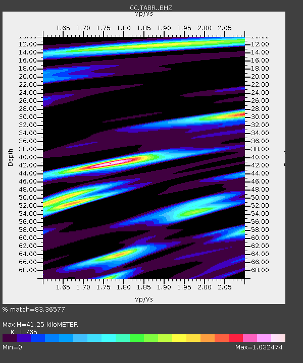
| Estimated Moho Depth: |
41.25 km |
| Estimated Crust Vp/Vs: |
1.76 |
| Assumed Crust Vp: |
6.597 km/s |
| Estimated Crust Vs: |
3.738 km/s |
| Estimated Crust Poisson's Ratio: |
0.26 |
|
| Radial Match: |
83.36577 % |
| Radial Bump: |
400 |
| Transverse Match: |
65.178825 % |
| Transverse Bump: |
400 |
| SOD ConfigId: |
31937991 |
| Insert Time: |
2023-09-22 09:40:14.288 +0000 |
| GWidth: |
2.5 |
| Max Bumps: |
400 |
| Tol: |
0.001 |
|

Signal To Noise
| Channel | StoN | STA | LTA |
| CC:TABR: :BHZ:20230908T09:22:37.720008Z | 13.370101 | 6.2166896E-7 | 4.6496954E-8 |
| CC:TABR: :BHN:20230908T09:22:37.720008Z | 4.583987 | 2.2018963E-7 | 4.8034522E-8 |
| CC:TABR: :BHE:20230908T09:22:37.720008Z | 2.1367888 | 1.6026966E-7 | 7.500491E-8 |
| Arrivals |
| Ps | 4.9 SECOND |
| PpPs | 17 SECOND |
| PsPs/PpSs | 22 SECOND |


