You are here: Home > Network List > CI - Caltech Regional Seismic Network Stations List
> Station MUR Murrieta > Earthquake Result Viewer
MUR Murrieta - Earthquake Result Viewer
| Earthquake location: |
South Of Kermadec Islands |
| Earthquake latitude/longitude: |
-32.7/-179.3 |
| Earthquake time(UTC): |
2023/09/08 (251) 09:09:58 GMT |
| Earthquake Depth: |
90 km |
| Earthquake Magnitude: |
6.6 mww |
| Earthquake Catalog/Contributor: |
NEIC PDE/us |
|
| Network: |
CI Caltech Regional Seismic Network |
| Station: |
MUR Murrieta |
| Lat/Lon: |
33.60 N/117.20 W |
| Elevation: |
562 m |
|
| Distance: |
88.1 deg |
| Az: |
47.569 deg |
| Baz: |
228.196 deg |
| Ray Param: |
0.04263822 |
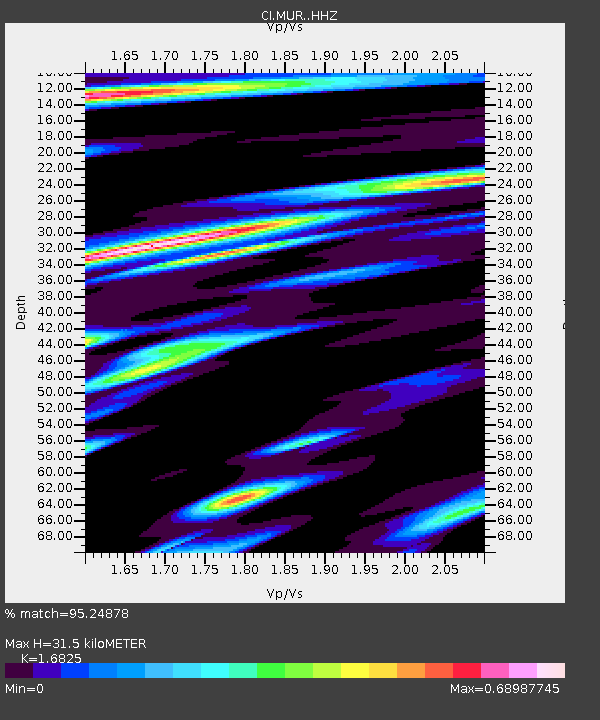
| Estimated Moho Depth: |
31.5 km |
| Estimated Crust Vp/Vs: |
1.68 |
| Assumed Crust Vp: |
6.264 km/s |
| Estimated Crust Vs: |
3.723 km/s |
| Estimated Crust Poisson's Ratio: |
0.23 |
|
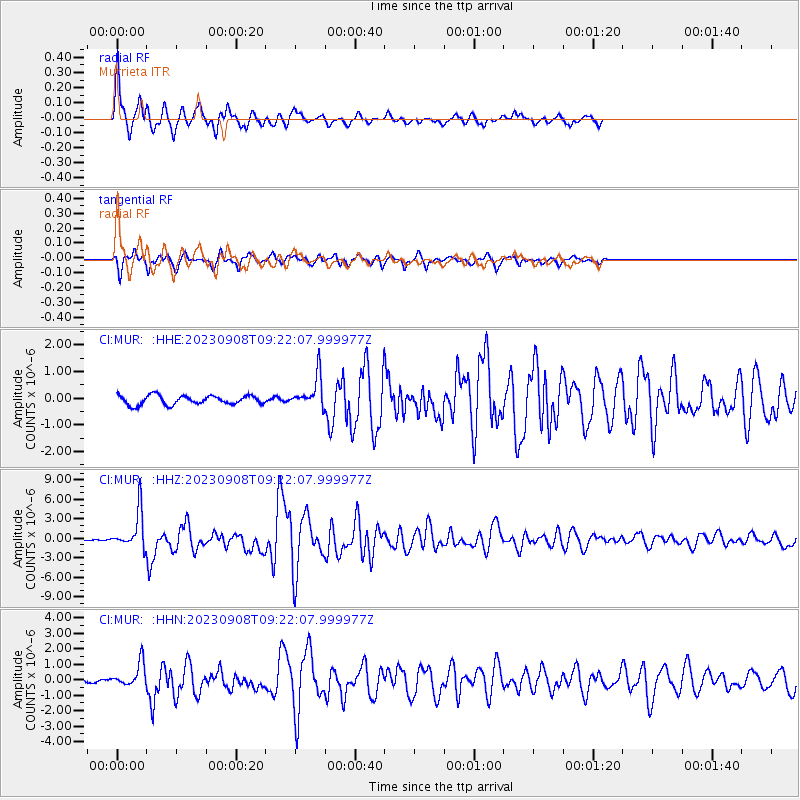
| Radial Match: |
95.24878 % |
| Radial Bump: |
321 |
| Transverse Match: |
90.96024 % |
| Transverse Bump: |
393 |
| SOD ConfigId: |
31937991 |
| Insert Time: |
2023-09-22 09:41:48.608 +0000 |
| GWidth: |
2.5 |
| Max Bumps: |
400 |
| Tol: |
0.001 |
|
Signal To Noise
| Channel | StoN | STA | LTA |
| CI:MUR: :HHZ:20230908T09:22:07.999977Z | 10.940176 | 2.874239E-6 | 2.6272326E-7 |
| CI:MUR: :HHN:20230908T09:22:07.999977Z | 6.176788 | 7.5327875E-7 | 1.2195315E-7 |
| CI:MUR: :HHE:20230908T09:22:07.999977Z | 3.5276408 | 5.976751E-7 | 1.694263E-7 |
| Arrivals |
| Ps | 3.5 SECOND |
| PpPs | 13 SECOND |
| PsPs/PpSs | 17 SECOND |


