You are here: Home > Network List > IU - Global Seismograph Network (GSN - IRIS/USGS) Stations List
> Station RSSD Black Hills, South Dakota, USA > Earthquake Result Viewer
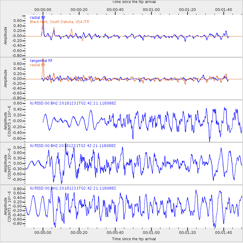
RSSD Black Hills, South Dakota, USA - Earthquake Result Viewer
*The percent match for this event was below the threshold and hence no stack was calculated.
| Earthquake location: |
Alaska Peninsula |
| Earthquake latitude/longitude: |
54.3/-161.4 |
| Earthquake time(UTC): |
2018/12/31 (365) 02:35:38 GMT |
| Earthquake Depth: |
34 km |
| Earthquake Magnitude: |
5.8 Mi |
| Earthquake Catalog/Contributor: |
NEIC PDE/at |
|
| Network: |
IU Global Seismograph Network (GSN - IRIS/USGS) |
| Station: |
RSSD Black Hills, South Dakota, USA |
| Lat/Lon: |
44.12 N/104.04 W |
| Elevation: |
2090 m |
|
| Distance: |
37.9 deg |
| Az: |
81.318 deg |
| Baz: |
306.366 deg |
| Ray Param: |
$rayparam |
*The percent match for this event was below the threshold and hence was not used in the summary stack. |
|
| Radial Match: |
71.31094 % |
| Radial Bump: |
368 |
| Transverse Match: |
51.504524 % |
| Transverse Bump: |
400 |
| SOD ConfigId: |
3201911 |
| Insert Time: |
2019-01-14 02:49:26.534 +0000 |
| GWidth: |
2.5 |
| Max Bumps: |
400 |
| Tol: |
0.001 |
|
Signal To Noise
| Channel | StoN | STA | LTA |
| IU:RSSD:00:BHZ:20181231T02:42:21.118988Z | 1.9701079 | 3.0387434E-7 | 1.5424249E-7 |
| IU:RSSD:00:BH1:20181231T02:42:21.118988Z | 2.134854 | 3.9666108E-7 | 1.8580243E-7 |
| IU:RSSD:00:BH2:20181231T02:42:21.118988Z | 0.76191056 | 1.0068664E-7 | 1.3215022E-7 |
| Arrivals |
| Ps | |
| PpPs | |
| PsPs/PpSs | |


