You are here: Home > Network List > CN - Canadian National Seismograph Network Stations List
> Station PNT Penticton, BC, CA > Earthquake Result Viewer
PNT Penticton, BC, CA - Earthquake Result Viewer
| Earthquake location: |
South Of Kermadec Islands |
| Earthquake latitude/longitude: |
-32.7/-179.3 |
| Earthquake time(UTC): |
2023/09/08 (251) 09:09:58 GMT |
| Earthquake Depth: |
90 km |
| Earthquake Magnitude: |
6.6 mww |
| Earthquake Catalog/Contributor: |
NEIC PDE/us |
|
| Network: |
CN Canadian National Seismograph Network |
| Station: |
PNT Penticton, BC, CA |
| Lat/Lon: |
49.32 N/119.63 W |
| Elevation: |
531 m |
|
| Distance: |
97.4 deg |
| Az: |
34.719 deg |
| Baz: |
227.199 deg |
| Ray Param: |
0.040164165 |
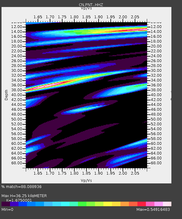
| Estimated Moho Depth: |
36.25 km |
| Estimated Crust Vp/Vs: |
1.68 |
| Assumed Crust Vp: |
6.419 km/s |
| Estimated Crust Vs: |
3.832 km/s |
| Estimated Crust Poisson's Ratio: |
0.22 |
|
| Radial Match: |
88.088936 % |
| Radial Bump: |
400 |
| Transverse Match: |
55.926807 % |
| Transverse Bump: |
400 |
| SOD ConfigId: |
31937991 |
| Insert Time: |
2023-09-22 09:43:33.692 +0000 |
| GWidth: |
2.5 |
| Max Bumps: |
400 |
| Tol: |
0.001 |
|

Signal To Noise
| Channel | StoN | STA | LTA |
| CN:PNT: :HHZ:20230908T09:22:50.400001Z | 8.224512 | 5.297412E-7 | 6.4410045E-8 |
| CN:PNT: :HHN:20230908T09:22:50.400001Z | 1.0873573 | 7.426281E-8 | 6.82966E-8 |
| CN:PNT: :HHE:20230908T09:22:50.400001Z | 2.2504704 | 1.4865672E-7 | 6.605584E-8 |
| Arrivals |
| Ps | 3.9 SECOND |
| PpPs | 15 SECOND |
| PsPs/PpSs | 19 SECOND |


