You are here: Home > Network List > IU - Global Seismograph Network (GSN - IRIS/USGS) Stations List
> Station PMSA Palmer Station, Antarctica > Earthquake Result Viewer
PMSA Palmer Station, Antarctica - Earthquake Result Viewer
| Earthquake location: |
South Of Kermadec Islands |
| Earthquake latitude/longitude: |
-32.7/-179.3 |
| Earthquake time(UTC): |
2023/09/08 (251) 09:09:58 GMT |
| Earthquake Depth: |
90 km |
| Earthquake Magnitude: |
6.6 mww |
| Earthquake Catalog/Contributor: |
NEIC PDE/us |
|
| Network: |
IU Global Seismograph Network (GSN - IRIS/USGS) |
| Station: |
PMSA Palmer Station, Antarctica |
| Lat/Lon: |
64.77 S/64.05 W |
| Elevation: |
40 m |
|
| Distance: |
70.6 deg |
| Az: |
155.741 deg |
| Baz: |
233.918 deg |
| Ray Param: |
0.054657377 |
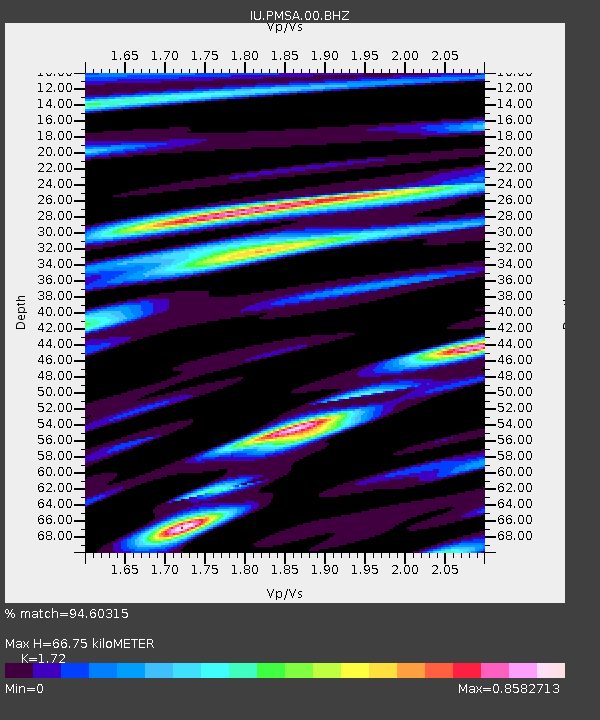
| Estimated Moho Depth: |
66.75 km |
| Estimated Crust Vp/Vs: |
1.72 |
| Assumed Crust Vp: |
6.183 km/s |
| Estimated Crust Vs: |
3.595 km/s |
| Estimated Crust Poisson's Ratio: |
0.24 |
|
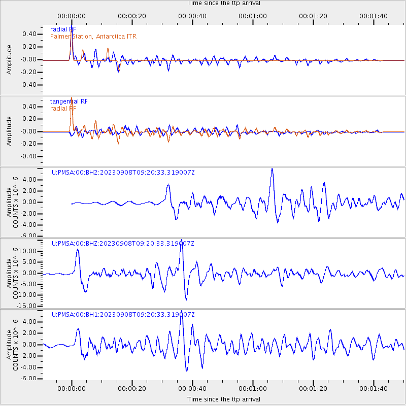
| Radial Match: |
94.60315 % |
| Radial Bump: |
314 |
| Transverse Match: |
91.55781 % |
| Transverse Bump: |
393 |
| SOD ConfigId: |
31937991 |
| Insert Time: |
2023-09-22 09:46:30.531 +0000 |
| GWidth: |
2.5 |
| Max Bumps: |
400 |
| Tol: |
0.001 |
|
Signal To Noise
| Channel | StoN | STA | LTA |
| IU:PMSA:00:BHZ:20230908T09:20:33.319007Z | 48.0853 | 5.8556307E-6 | 1.217759E-7 |
| IU:PMSA:00:BH1:20230908T09:20:33.319007Z | 7.306059 | 1.6192399E-6 | 2.2162973E-7 |
| IU:PMSA:00:BH2:20230908T09:20:33.319007Z | 9.435857 | 1.7247501E-6 | 1.827868E-7 |
| Arrivals |
| Ps | 8.0 SECOND |
| PpPs | 28 SECOND |
| PsPs/PpSs | 36 SECOND |


