You are here: Home > Network List > NN - Western Great Basin/Eastern Sierra Nevada Stations List
> Station ZPR Zephyr Cove, Lake Tahoe, Nevada > Earthquake Result Viewer
ZPR Zephyr Cove, Lake Tahoe, Nevada - Earthquake Result Viewer
| Earthquake location: |
South Of Kermadec Islands |
| Earthquake latitude/longitude: |
-32.7/-179.3 |
| Earthquake time(UTC): |
2023/09/08 (251) 09:09:58 GMT |
| Earthquake Depth: |
90 km |
| Earthquake Magnitude: |
6.6 mww |
| Earthquake Catalog/Contributor: |
NEIC PDE/us |
|
| Network: |
NN Western Great Basin/Eastern Sierra Nevada |
| Station: |
ZPR Zephyr Cove, Lake Tahoe, Nevada |
| Lat/Lon: |
39.01 N/119.94 W |
| Elevation: |
2001 m |
|
| Distance: |
90.2 deg |
| Az: |
42.095 deg |
| Baz: |
226.495 deg |
| Ray Param: |
0.04170656 |
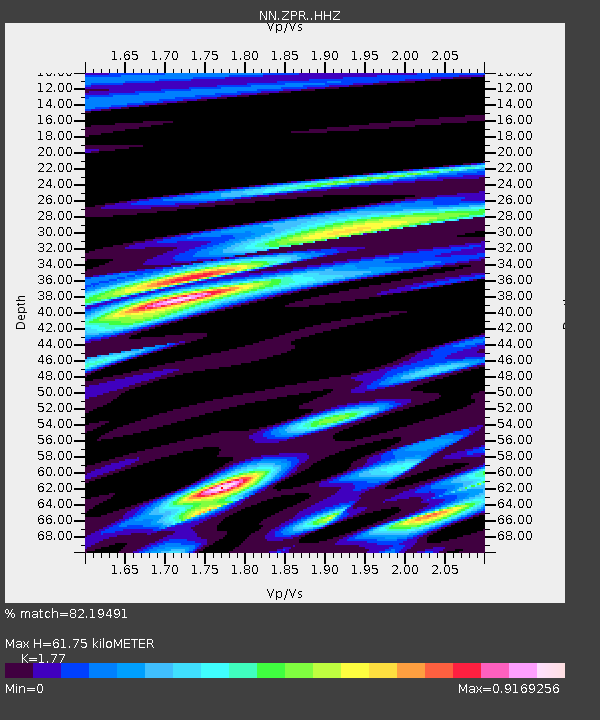
| Estimated Moho Depth: |
61.75 km |
| Estimated Crust Vp/Vs: |
1.77 |
| Assumed Crust Vp: |
6.279 km/s |
| Estimated Crust Vs: |
3.547 km/s |
| Estimated Crust Poisson's Ratio: |
0.27 |
|
| Radial Match: |
82.19491 % |
| Radial Bump: |
400 |
| Transverse Match: |
87.289635 % |
| Transverse Bump: |
400 |
| SOD ConfigId: |
31937991 |
| Insert Time: |
2023-09-22 09:48:29.258 +0000 |
| GWidth: |
2.5 |
| Max Bumps: |
400 |
| Tol: |
0.001 |
|

Signal To Noise
| Channel | StoN | STA | LTA |
| NN:ZPR: :HHZ:20230908T09:22:17.478004Z | 16.687696 | 1.4380537E-6 | 8.617449E-8 |
| NN:ZPR: :HHN:20230908T09:22:17.478004Z | 0.9849489 | 1.9388229E-7 | 1.9684502E-7 |
| NN:ZPR: :HHE:20230908T09:22:17.478004Z | 1.065578 | 3.394964E-7 | 3.1860307E-7 |
| Arrivals |
| Ps | 7.7 SECOND |
| PpPs | 27 SECOND |
| PsPs/PpSs | 34 SECOND |


