You are here: Home > Network List > SB - UC Santa Barbara Engineering Seismology Network () Stations List
> Station VAFB2 Taft Rd, Vandenberg AFB, CA, USA > Earthquake Result Viewer
VAFB2 Taft Rd, Vandenberg AFB, CA, USA - Earthquake Result Viewer
| Earthquake location: |
South Of Kermadec Islands |
| Earthquake latitude/longitude: |
-32.7/-179.3 |
| Earthquake time(UTC): |
2023/09/08 (251) 09:09:58 GMT |
| Earthquake Depth: |
90 km |
| Earthquake Magnitude: |
6.6 mww |
| Earthquake Catalog/Contributor: |
NEIC PDE/us |
|
| Network: |
SB UC Santa Barbara Engineering Seismology Network () |
| Station: |
VAFB2 Taft Rd, Vandenberg AFB, CA, USA |
| Lat/Lon: |
34.84 N/120.58 W |
| Elevation: |
91 m |
|
| Distance: |
86.9 deg |
| Az: |
44.748 deg |
| Baz: |
226.177 deg |
| Ray Param: |
0.043525185 |
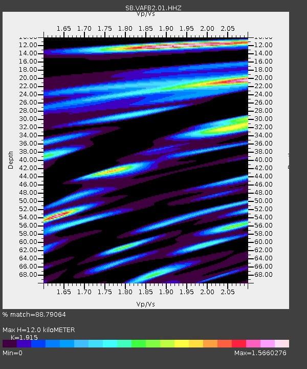
| Estimated Moho Depth: |
12.0 km |
| Estimated Crust Vp/Vs: |
1.91 |
| Assumed Crust Vp: |
6.183 km/s |
| Estimated Crust Vs: |
3.229 km/s |
| Estimated Crust Poisson's Ratio: |
0.31 |
|
| Radial Match: |
88.79064 % |
| Radial Bump: |
400 |
| Transverse Match: |
75.673416 % |
| Transverse Bump: |
400 |
| SOD ConfigId: |
31937991 |
| Insert Time: |
2023-09-22 09:50:37.058 +0000 |
| GWidth: |
2.5 |
| Max Bumps: |
400 |
| Tol: |
0.001 |
|

Signal To Noise
| Channel | StoN | STA | LTA |
| SB:VAFB2:01:HHZ:20230908T09:22:02.184974Z | 10.431846 | 3.2106225E-6 | 3.0777127E-7 |
| SB:VAFB2:01:HHN:20230908T09:22:02.184974Z | 6.7952766 | 1.1045789E-6 | 1.6255099E-7 |
| SB:VAFB2:01:HHE:20230908T09:22:02.184974Z | 3.3563204 | 1.3426728E-6 | 4.000431E-7 |
| Arrivals |
| Ps | 1.8 SECOND |
| PpPs | 5.5 SECOND |
| PsPs/PpSs | 7.4 SECOND |


