You are here: Home > Network List > TM - Thai Seismic Monitoring Network Stations List
> Station LOEI Nam Man, Loei > Earthquake Result Viewer
LOEI Nam Man, Loei - Earthquake Result Viewer
| Earthquake location: |
South Of Kermadec Islands |
| Earthquake latitude/longitude: |
-32.7/-179.3 |
| Earthquake time(UTC): |
2023/09/08 (251) 09:09:58 GMT |
| Earthquake Depth: |
90 km |
| Earthquake Magnitude: |
6.6 mww |
| Earthquake Catalog/Contributor: |
NEIC PDE/us |
|
| Network: |
TM Thai Seismic Monitoring Network |
| Station: |
LOEI Nam Man, Loei |
| Lat/Lon: |
17.51 N/101.62 E |
| Elevation: |
305 m |
|
| Distance: |
90.5 deg |
| Az: |
290.452 deg |
| Baz: |
124.141 deg |
| Ray Param: |
0.041682776 |
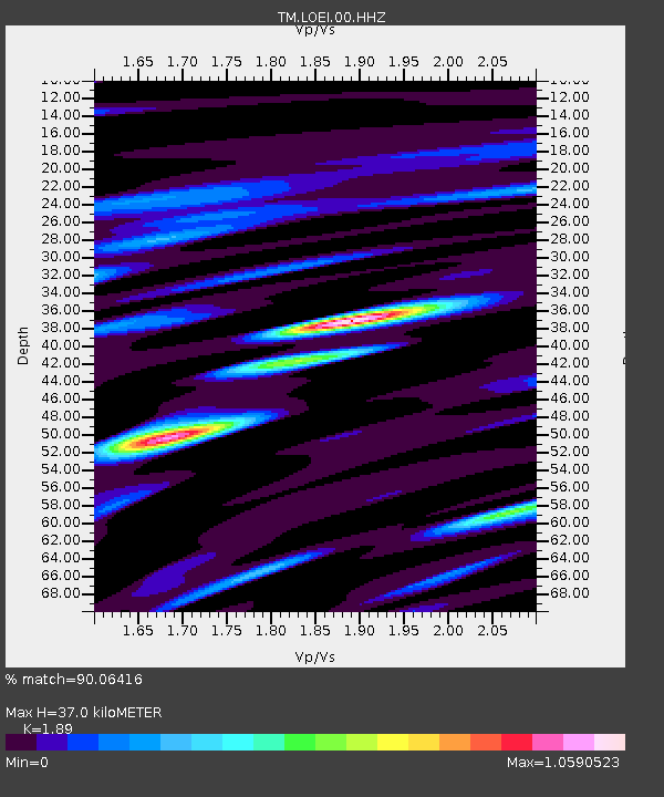
| Estimated Moho Depth: |
37.0 km |
| Estimated Crust Vp/Vs: |
1.89 |
| Assumed Crust Vp: |
6.35 km/s |
| Estimated Crust Vs: |
3.36 km/s |
| Estimated Crust Poisson's Ratio: |
0.31 |
|
| Radial Match: |
90.06416 % |
| Radial Bump: |
400 |
| Transverse Match: |
86.04253 % |
| Transverse Bump: |
400 |
| SOD ConfigId: |
31937991 |
| Insert Time: |
2023-09-22 09:51:08.176 +0000 |
| GWidth: |
2.5 |
| Max Bumps: |
400 |
| Tol: |
0.001 |
|

Signal To Noise
| Channel | StoN | STA | LTA |
| TM:LOEI:00:HHZ:20230908T09:22:18.970008Z | 16.04924 | 2.6039263E-6 | 1.6224608E-7 |
| TM:LOEI:00:HHN:20230908T09:22:18.970008Z | 12.901744 | 4.9218886E-7 | 3.8149018E-8 |
| TM:LOEI:00:HHE:20230908T09:22:18.970008Z | 17.00321 | 1.0683601E-6 | 6.283285E-8 |
| Arrivals |
| Ps | 5.3 SECOND |
| PpPs | 17 SECOND |
| PsPs/PpSs | 22 SECOND |


