You are here: Home > Network List > US - United States National Seismic Network Stations List
> Station CBKS Cedar Bluff, Kansas, USA > Earthquake Result Viewer
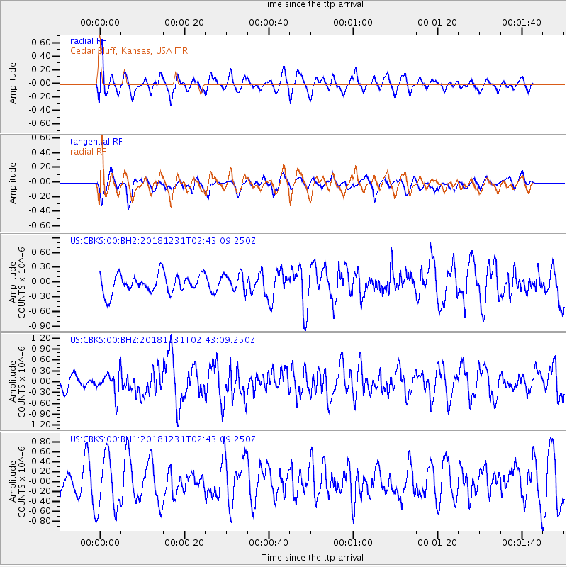
CBKS Cedar Bluff, Kansas, USA - Earthquake Result Viewer
*The percent match for this event was below the threshold and hence no stack was calculated.
| Earthquake location: |
Alaska Peninsula |
| Earthquake latitude/longitude: |
54.3/-161.4 |
| Earthquake time(UTC): |
2018/12/31 (365) 02:35:38 GMT |
| Earthquake Depth: |
34 km |
| Earthquake Magnitude: |
5.8 Mi |
| Earthquake Catalog/Contributor: |
NEIC PDE/at |
|
| Network: |
US United States National Seismic Network |
| Station: |
CBKS Cedar Bluff, Kansas, USA |
| Lat/Lon: |
38.81 N/99.74 W |
| Elevation: |
677 m |
|
| Distance: |
43.7 deg |
| Az: |
84.51 deg |
| Baz: |
311.626 deg |
| Ray Param: |
$rayparam |
*The percent match for this event was below the threshold and hence was not used in the summary stack. |
|
| Radial Match: |
57.710213 % |
| Radial Bump: |
400 |
| Transverse Match: |
57.87544 % |
| Transverse Bump: |
400 |
| SOD ConfigId: |
3201911 |
| Insert Time: |
2019-01-14 02:51:43.739 +0000 |
| GWidth: |
2.5 |
| Max Bumps: |
400 |
| Tol: |
0.001 |
|
Signal To Noise
| Channel | StoN | STA | LTA |
| US:CBKS:00:BHZ:20181231T02:43:09.250Z | 2.3764563 | 3.2919516E-7 | 1.3852355E-7 |
| US:CBKS:00:BH1:20181231T02:43:09.250Z | 2.5832565 | 5.480691E-7 | 2.1216209E-7 |
| US:CBKS:00:BH2:20181231T02:43:09.250Z | 0.9484151 | 1.7628876E-7 | 1.8587721E-7 |
| Arrivals |
| Ps | |
| PpPs | |
| PsPs/PpSs | |


