You are here: Home > Network List > UO - University of Oregon Regional Network Stations List
> Station TRASK Tillamook, OR, USA > Earthquake Result Viewer
TRASK Tillamook, OR, USA - Earthquake Result Viewer
| Earthquake location: |
South Of Kermadec Islands |
| Earthquake latitude/longitude: |
-32.7/-179.3 |
| Earthquake time(UTC): |
2023/09/08 (251) 09:09:58 GMT |
| Earthquake Depth: |
90 km |
| Earthquake Magnitude: |
6.6 mww |
| Earthquake Catalog/Contributor: |
NEIC PDE/us |
|
| Network: |
UO University of Oregon Regional Network |
| Station: |
TRASK Tillamook, OR, USA |
| Lat/Lon: |
45.39 N/123.52 W |
| Elevation: |
786 m |
|
| Distance: |
92.7 deg |
| Az: |
35.688 deg |
| Baz: |
224.252 deg |
| Ray Param: |
0.041361056 |
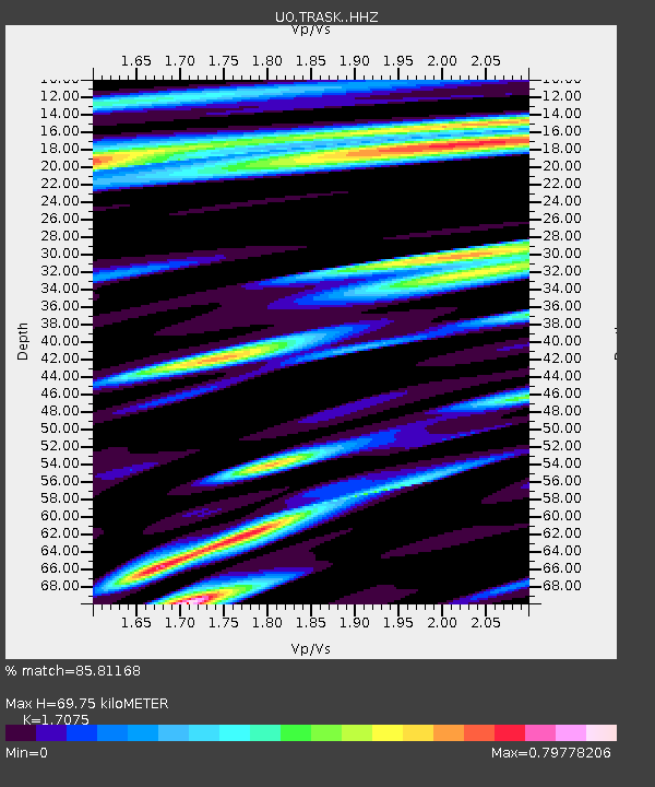
| Estimated Moho Depth: |
69.75 km |
| Estimated Crust Vp/Vs: |
1.71 |
| Assumed Crust Vp: |
6.566 km/s |
| Estimated Crust Vs: |
3.845 km/s |
| Estimated Crust Poisson's Ratio: |
0.24 |
|
| Radial Match: |
85.81168 % |
| Radial Bump: |
374 |
| Transverse Match: |
87.608574 % |
| Transverse Bump: |
369 |
| SOD ConfigId: |
31937991 |
| Insert Time: |
2023-09-22 09:54:15.900 +0000 |
| GWidth: |
2.5 |
| Max Bumps: |
400 |
| Tol: |
0.001 |
|

Signal To Noise
| Channel | StoN | STA | LTA |
| UO:TRASK: :HHZ:20230908T09:22:29.369972Z | 9.741078 | 1.6078808E-6 | 1.6506189E-7 |
| UO:TRASK: :HHN:20230908T09:22:29.369972Z | 1.2628269 | 2.6692018E-7 | 2.1136721E-7 |
| UO:TRASK: :HHE:20230908T09:22:29.369972Z | 2.0156186 | 3.0072016E-7 | 1.4919497E-7 |
| Arrivals |
| Ps | 7.7 SECOND |
| PpPs | 28 SECOND |
| PsPs/PpSs | 36 SECOND |


