You are here: Home > Network List > UU - University of Utah Regional Network Stations List
> Station FSB1 FORGE surface borehole 1, UT, USA > Earthquake Result Viewer
FSB1 FORGE surface borehole 1, UT, USA - Earthquake Result Viewer
| Earthquake location: |
South Of Kermadec Islands |
| Earthquake latitude/longitude: |
-32.7/-179.3 |
| Earthquake time(UTC): |
2023/09/08 (251) 09:09:58 GMT |
| Earthquake Depth: |
90 km |
| Earthquake Magnitude: |
6.6 mww |
| Earthquake Catalog/Contributor: |
NEIC PDE/us |
|
| Network: |
UU University of Utah Regional Network |
| Station: |
FSB1 FORGE surface borehole 1, UT, USA |
| Lat/Lon: |
38.48 N/112.89 W |
| Elevation: |
1697 m |
|
| Distance: |
93.9 deg |
| Az: |
46.133 deg |
| Baz: |
230.746 deg |
| Ray Param: |
0.04110494 |
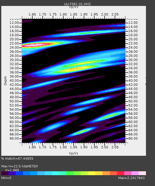
| Estimated Moho Depth: |
22.5 km |
| Estimated Crust Vp/Vs: |
1.66 |
| Assumed Crust Vp: |
6.276 km/s |
| Estimated Crust Vs: |
3.769 km/s |
| Estimated Crust Poisson's Ratio: |
0.22 |
|
| Radial Match: |
87.44655 % |
| Radial Bump: |
400 |
| Transverse Match: |
84.36905 % |
| Transverse Bump: |
400 |
| SOD ConfigId: |
31937991 |
| Insert Time: |
2023-09-22 09:55:31.007 +0000 |
| GWidth: |
2.5 |
| Max Bumps: |
400 |
| Tol: |
0.001 |
|

Signal To Noise
| Channel | StoN | STA | LTA |
| UU:FSB1:01:HHZ:20230908T09:22:34.894996Z | 4.018196 | 7.5291865E-7 | 1.8737728E-7 |
| UU:FSB1:01:HH1:20230908T09:22:34.894996Z | 2.6940315 | 5.6430383E-7 | 2.0946443E-7 |
| UU:FSB1:01:HH2:20230908T09:22:34.894996Z | 0.74154425 | 1.4006294E-7 | 1.8888008E-7 |
| Arrivals |
| Ps | 2.4 SECOND |
| PpPs | 9.4 SECOND |
| PsPs/PpSs | 12 SECOND |


