You are here: Home > Network List > UU - University of Utah Regional Network Stations List
> Station MOUT Mount Ogden, UT, USA > Earthquake Result Viewer
MOUT Mount Ogden, UT, USA - Earthquake Result Viewer
| Earthquake location: |
South Of Kermadec Islands |
| Earthquake latitude/longitude: |
-32.7/-179.3 |
| Earthquake time(UTC): |
2023/09/08 (251) 09:09:58 GMT |
| Earthquake Depth: |
90 km |
| Earthquake Magnitude: |
6.6 mww |
| Earthquake Catalog/Contributor: |
NEIC PDE/us |
|
| Network: |
UU University of Utah Regional Network |
| Station: |
MOUT Mount Ogden, UT, USA |
| Lat/Lon: |
41.20 N/111.88 W |
| Elevation: |
2748 m |
|
| Distance: |
96.3 deg |
| Az: |
44.505 deg |
| Baz: |
231.537 deg |
| Ray Param: |
0.040503353 |
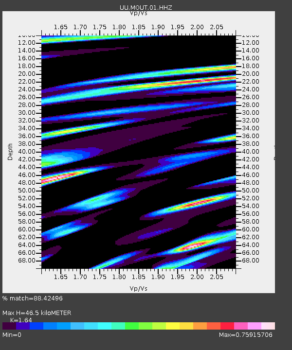
| Estimated Moho Depth: |
46.5 km |
| Estimated Crust Vp/Vs: |
1.64 |
| Assumed Crust Vp: |
6.155 km/s |
| Estimated Crust Vs: |
3.753 km/s |
| Estimated Crust Poisson's Ratio: |
0.20 |
|
| Radial Match: |
88.42496 % |
| Radial Bump: |
400 |
| Transverse Match: |
66.39348 % |
| Transverse Bump: |
400 |
| SOD ConfigId: |
31937991 |
| Insert Time: |
2023-09-22 09:55:38.530 +0000 |
| GWidth: |
2.5 |
| Max Bumps: |
400 |
| Tol: |
0.001 |
|

Signal To Noise
| Channel | StoN | STA | LTA |
| UU:MOUT:01:HHZ:20230908T09:22:45.350013Z | 12.890882 | 8.59658E-7 | 6.668729E-8 |
| UU:MOUT:01:HHN:20230908T09:22:45.350013Z | 1.3342414 | 2.0817008E-7 | 1.5602131E-7 |
| UU:MOUT:01:HHE:20230908T09:22:45.350013Z | 1.522012 | 2.3572542E-7 | 1.5487751E-7 |
| Arrivals |
| Ps | 4.9 SECOND |
| PpPs | 20 SECOND |
| PsPs/PpSs | 24 SECOND |


