You are here: Home > Network List > UU - University of Utah Regional Network Stations List
> Station FPU Francis Peak, UT, USA > Earthquake Result Viewer
FPU Francis Peak, UT, USA - Earthquake Result Viewer
| Earthquake location: |
South Of Kermadec Islands |
| Earthquake latitude/longitude: |
-32.7/-179.3 |
| Earthquake time(UTC): |
2023/09/08 (251) 09:09:58 GMT |
| Earthquake Depth: |
90 km |
| Earthquake Magnitude: |
6.6 mww |
| Earthquake Catalog/Contributor: |
NEIC PDE/us |
|
| Network: |
UU University of Utah Regional Network |
| Station: |
FPU Francis Peak, UT, USA |
| Lat/Lon: |
41.03 N/111.84 W |
| Elevation: |
2816 m |
|
| Distance: |
96.2 deg |
| Az: |
44.661 deg |
| Baz: |
231.548 deg |
| Ray Param: |
0.04052682 |
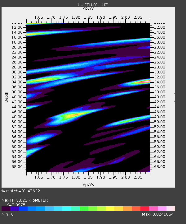
| Estimated Moho Depth: |
33.25 km |
| Estimated Crust Vp/Vs: |
2.10 |
| Assumed Crust Vp: |
6.155 km/s |
| Estimated Crust Vs: |
2.934 km/s |
| Estimated Crust Poisson's Ratio: |
0.35 |
|
| Radial Match: |
91.47622 % |
| Radial Bump: |
400 |
| Transverse Match: |
83.561325 % |
| Transverse Bump: |
400 |
| SOD ConfigId: |
31937991 |
| Insert Time: |
2023-09-22 09:55:52.299 +0000 |
| GWidth: |
2.5 |
| Max Bumps: |
400 |
| Tol: |
0.001 |
|

Signal To Noise
| Channel | StoN | STA | LTA |
| UU:FPU:01:HHZ:20230908T09:22:44.980018Z | 13.398405 | 8.15819E-7 | 6.088926E-8 |
| UU:FPU:01:HHN:20230908T09:22:44.980018Z | 2.498198 | 1.4853161E-7 | 5.94555E-8 |
| UU:FPU:01:HHE:20230908T09:22:44.980018Z | 2.254575 | 2.5775353E-7 | 1.14324656E-7 |
| Arrivals |
| Ps | 6.0 SECOND |
| PpPs | 16 SECOND |
| PsPs/PpSs | 23 SECOND |


