You are here: Home > Network List > UW - Pacific Northwest Regional Seismic Network Stations List
> Station LCCR Clarks, OR, USA > Earthquake Result Viewer
LCCR Clarks, OR, USA - Earthquake Result Viewer
*The percent match for this event was below the threshold and hence no stack was calculated.
| Earthquake location: |
South Of Kermadec Islands |
| Earthquake latitude/longitude: |
-32.7/-179.3 |
| Earthquake time(UTC): |
2023/09/08 (251) 09:09:58 GMT |
| Earthquake Depth: |
90 km |
| Earthquake Magnitude: |
6.6 mww |
| Earthquake Catalog/Contributor: |
NEIC PDE/us |
|
| Network: |
UW Pacific Northwest Regional Seismic Network |
| Station: |
LCCR Clarks, OR, USA |
| Lat/Lon: |
45.21 N/122.48 W |
| Elevation: |
271 m |
|
| Distance: |
93.1 deg |
| Az: |
36.343 deg |
| Baz: |
224.96 deg |
| Ray Param: |
$rayparam |
*The percent match for this event was below the threshold and hence was not used in the summary stack. |
|
| Radial Match: |
78.84254 % |
| Radial Bump: |
400 |
| Transverse Match: |
79.08619 % |
| Transverse Bump: |
400 |
| SOD ConfigId: |
31937991 |
| Insert Time: |
2023-09-22 09:57:42.941 +0000 |
| GWidth: |
2.5 |
| Max Bumps: |
400 |
| Tol: |
0.001 |
|
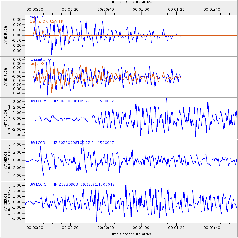
Signal To Noise
| Channel | StoN | STA | LTA |
| UW:LCCR: :HHZ:20230908T09:22:31.150001Z | 9.6443615 | 1.5959014E-6 | 1.6547507E-7 |
| UW:LCCR: :HHN:20230908T09:22:31.150001Z | 2.3776267 | 4.839037E-7 | 2.0352383E-7 |
| UW:LCCR: :HHE:20230908T09:22:31.150001Z | 1.5331076 | 3.8658294E-7 | 2.5215644E-7 |
| Arrivals |
| Ps | |
| PpPs | |
| PsPs/PpSs | |


