You are here: Home > Network List > UW - Pacific Northwest Regional Seismic Network Stations List
> Station LOPEZ Johns Point, Lopez Island, WA, USA > Earthquake Result Viewer
LOPEZ Johns Point, Lopez Island, WA, USA - Earthquake Result Viewer
| Earthquake location: |
South Of Kermadec Islands |
| Earthquake latitude/longitude: |
-32.7/-179.3 |
| Earthquake time(UTC): |
2023/09/08 (251) 09:09:58 GMT |
| Earthquake Depth: |
90 km |
| Earthquake Magnitude: |
6.6 mww |
| Earthquake Catalog/Contributor: |
NEIC PDE/us |
|
| Network: |
UW Pacific Northwest Regional Seismic Network |
| Station: |
LOPEZ Johns Point, Lopez Island, WA, USA |
| Lat/Lon: |
48.44 N/122.89 W |
| Elevation: |
10 m |
|
| Distance: |
95.2 deg |
| Az: |
33.856 deg |
| Baz: |
224.843 deg |
| Ray Param: |
0.040790137 |
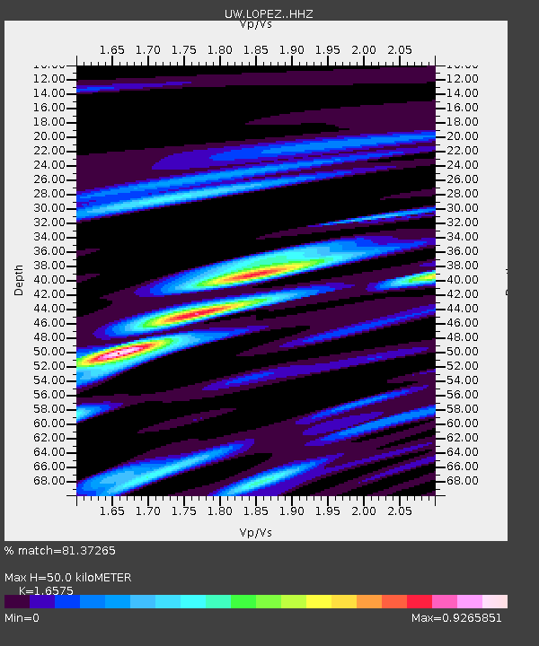
| Estimated Moho Depth: |
50.0 km |
| Estimated Crust Vp/Vs: |
1.66 |
| Assumed Crust Vp: |
6.566 km/s |
| Estimated Crust Vs: |
3.961 km/s |
| Estimated Crust Poisson's Ratio: |
0.21 |
|
| Radial Match: |
81.37265 % |
| Radial Bump: |
400 |
| Transverse Match: |
66.19894 % |
| Transverse Bump: |
400 |
| SOD ConfigId: |
31937991 |
| Insert Time: |
2023-09-22 09:57:57.696 +0000 |
| GWidth: |
2.5 |
| Max Bumps: |
400 |
| Tol: |
0.001 |
|

Signal To Noise
| Channel | StoN | STA | LTA |
| UW:LOPEZ: :HHZ:20230908T09:22:40.68003Z | 8.034853 | 7.697287E-7 | 9.579873E-8 |
| UW:LOPEZ: :HHN:20230908T09:22:40.68003Z | 1.355571 | 1.3117534E-7 | 9.676759E-8 |
| UW:LOPEZ: :HHE:20230908T09:22:40.68003Z | 2.0777364 | 2.112636E-7 | 1.01679696E-7 |
| Arrivals |
| Ps | 5.1 SECOND |
| PpPs | 20 SECOND |
| PsPs/PpSs | 25 SECOND |


