You are here: Home > Network List > UW - Pacific Northwest Regional Seismic Network Stations List
> Station PAN4H Panhandle 4H Camp, Shelton, WA, USA > Earthquake Result Viewer
PAN4H Panhandle 4H Camp, Shelton, WA, USA - Earthquake Result Viewer
| Earthquake location: |
South Of Kermadec Islands |
| Earthquake latitude/longitude: |
-32.7/-179.3 |
| Earthquake time(UTC): |
2023/09/08 (251) 09:09:58 GMT |
| Earthquake Depth: |
90 km |
| Earthquake Magnitude: |
6.6 mww |
| Earthquake Catalog/Contributor: |
NEIC PDE/us |
|
| Network: |
UW Pacific Northwest Regional Seismic Network |
| Station: |
PAN4H Panhandle 4H Camp, Shelton, WA, USA |
| Lat/Lon: |
47.18 N/123.27 W |
| Elevation: |
132 m |
|
| Distance: |
94.1 deg |
| Az: |
34.562 deg |
| Baz: |
224.503 deg |
| Ray Param: |
0.04105986 |
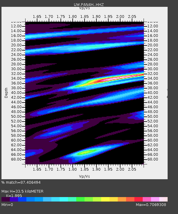
| Estimated Moho Depth: |
33.5 km |
| Estimated Crust Vp/Vs: |
2.00 |
| Assumed Crust Vp: |
6.566 km/s |
| Estimated Crust Vs: |
3.291 km/s |
| Estimated Crust Poisson's Ratio: |
0.33 |
|
| Radial Match: |
87.406494 % |
| Radial Bump: |
400 |
| Transverse Match: |
73.4961 % |
| Transverse Bump: |
400 |
| SOD ConfigId: |
31937991 |
| Insert Time: |
2023-09-22 09:58:35.208 +0000 |
| GWidth: |
2.5 |
| Max Bumps: |
400 |
| Tol: |
0.001 |
|

Signal To Noise
| Channel | StoN | STA | LTA |
| UW:PAN4H: :HHZ:20230908T09:22:35.780006Z | 12.38726 | 9.962968E-7 | 8.042915E-8 |
| UW:PAN4H: :HHN:20230908T09:22:35.780006Z | 2.506016 | 2.872763E-7 | 1.1463465E-7 |
| UW:PAN4H: :HHE:20230908T09:22:35.780006Z | 1.4403325 | 1.7307005E-7 | 1.201598E-7 |
| Arrivals |
| Ps | 5.2 SECOND |
| PpPs | 15 SECOND |
| PsPs/PpSs | 20 SECOND |


