You are here: Home > Network List > UW - Pacific Northwest Regional Seismic Network Stations List
> Station SKOKO Rock Peak, WA, USA > Earthquake Result Viewer
SKOKO Rock Peak, WA, USA - Earthquake Result Viewer
| Earthquake location: |
South Of Kermadec Islands |
| Earthquake latitude/longitude: |
-32.7/-179.3 |
| Earthquake time(UTC): |
2023/09/08 (251) 09:09:58 GMT |
| Earthquake Depth: |
90 km |
| Earthquake Magnitude: |
6.6 mww |
| Earthquake Catalog/Contributor: |
NEIC PDE/us |
|
| Network: |
UW Pacific Northwest Regional Seismic Network |
| Station: |
SKOKO Rock Peak, WA, USA |
| Lat/Lon: |
47.41 N/123.37 W |
| Elevation: |
950 m |
|
| Distance: |
94.3 deg |
| Az: |
34.351 deg |
| Baz: |
224.448 deg |
| Ray Param: |
0.04103127 |
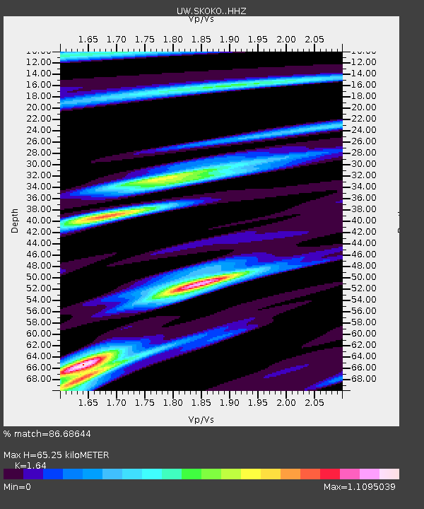
| Estimated Moho Depth: |
65.25 km |
| Estimated Crust Vp/Vs: |
1.64 |
| Assumed Crust Vp: |
6.566 km/s |
| Estimated Crust Vs: |
4.004 km/s |
| Estimated Crust Poisson's Ratio: |
0.20 |
|
| Radial Match: |
86.68644 % |
| Radial Bump: |
320 |
| Transverse Match: |
73.892204 % |
| Transverse Bump: |
400 |
| SOD ConfigId: |
31937991 |
| Insert Time: |
2023-09-22 09:59:05.820 +0000 |
| GWidth: |
2.5 |
| Max Bumps: |
400 |
| Tol: |
0.001 |
|

Signal To Noise
| Channel | StoN | STA | LTA |
| UW:SKOKO: :HHZ:20230908T09:22:36.329994Z | 10.914063 | 7.485467E-7 | 6.8585514E-8 |
| UW:SKOKO: :HHN:20230908T09:22:36.329994Z | 2.8731086 | 2.5282418E-7 | 8.799674E-8 |
| UW:SKOKO: :HHE:20230908T09:22:36.329994Z | 1.3427515 | 1.4945127E-7 | 1.1130225E-7 |
| Arrivals |
| Ps | 6.5 SECOND |
| PpPs | 26 SECOND |
| PsPs/PpSs | 32 SECOND |


