You are here: Home > Network List > UW - Pacific Northwest Regional Seismic Network Stations List
> Station WA2 Wahluke Slope previous ISC code: WAH2 > Earthquake Result Viewer
WA2 Wahluke Slope previous ISC code: WAH2 - Earthquake Result Viewer
| Earthquake location: |
South Of Kermadec Islands |
| Earthquake latitude/longitude: |
-32.7/-179.3 |
| Earthquake time(UTC): |
2023/09/08 (251) 09:09:58 GMT |
| Earthquake Depth: |
90 km |
| Earthquake Magnitude: |
6.6 mww |
| Earthquake Catalog/Contributor: |
NEIC PDE/us |
|
| Network: |
UW Pacific Northwest Regional Seismic Network |
| Station: |
WA2 Wahluke Slope previous ISC code: WAH2 |
| Lat/Lon: |
46.76 N/119.57 W |
| Elevation: |
244 m |
|
| Distance: |
95.7 deg |
| Az: |
36.64 deg |
| Baz: |
227.024 deg |
| Ray Param: |
0.040669866 |
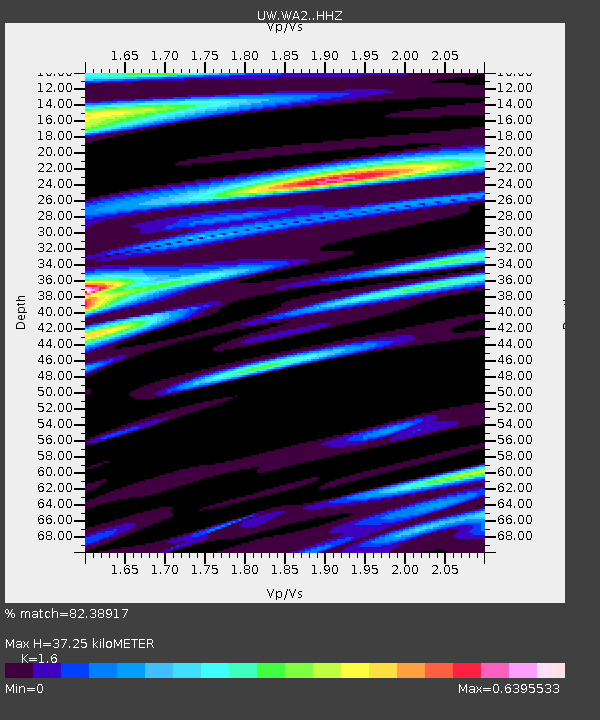
| Estimated Moho Depth: |
37.25 km |
| Estimated Crust Vp/Vs: |
1.60 |
| Assumed Crust Vp: |
6.419 km/s |
| Estimated Crust Vs: |
4.012 km/s |
| Estimated Crust Poisson's Ratio: |
0.18 |
|
| Radial Match: |
82.38917 % |
| Radial Bump: |
400 |
| Transverse Match: |
73.29821 % |
| Transverse Bump: |
400 |
| SOD ConfigId: |
31937991 |
| Insert Time: |
2023-09-22 09:59:35.849 +0000 |
| GWidth: |
2.5 |
| Max Bumps: |
400 |
| Tol: |
0.001 |
|

Signal To Noise
| Channel | StoN | STA | LTA |
| UW:WA2: :HHZ:20230908T09:22:42.689979Z | 7.030753 | 7.9301924E-7 | 1.1279293E-7 |
| UW:WA2: :HHN:20230908T09:22:42.689979Z | 2.3884633 | 1.6400702E-7 | 6.866634E-8 |
| UW:WA2: :HHE:20230908T09:22:42.689979Z | 3.10268 | 1.8875014E-7 | 6.083455E-8 |
| Arrivals |
| Ps | 3.6 SECOND |
| PpPs | 15 SECOND |
| PsPs/PpSs | 18 SECOND |


