You are here: Home > Network List > IW - Intermountain West Stations List
> Station MOOW Moose Ponds, Wyoming, USA > Earthquake Result Viewer
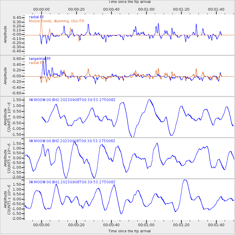
MOOW Moose Ponds, Wyoming, USA - Earthquake Result Viewer
*The percent match for this event was below the threshold and hence no stack was calculated.
| Earthquake location: |
Near East Coast Of Honshu, Japan |
| Earthquake latitude/longitude: |
39.0/142.1 |
| Earthquake time(UTC): |
2023/09/08 (251) 09:28:50 GMT |
| Earthquake Depth: |
54 km |
| Earthquake Magnitude: |
5.5 mb |
| Earthquake Catalog/Contributor: |
NEIC PDE/us |
|
| Network: |
IW Intermountain West |
| Station: |
MOOW Moose Ponds, Wyoming, USA |
| Lat/Lon: |
43.75 N/110.74 W |
| Elevation: |
2128 m |
|
| Distance: |
74.6 deg |
| Az: |
45.897 deg |
| Baz: |
309.414 deg |
| Ray Param: |
$rayparam |
*The percent match for this event was below the threshold and hence was not used in the summary stack. |
|
| Radial Match: |
66.09333 % |
| Radial Bump: |
378 |
| Transverse Match: |
77.63425 % |
| Transverse Bump: |
400 |
| SOD ConfigId: |
31937991 |
| Insert Time: |
2023-09-22 10:14:23.604 +0000 |
| GWidth: |
2.5 |
| Max Bumps: |
400 |
| Tol: |
0.001 |
|
Signal To Noise
| Channel | StoN | STA | LTA |
| IW:MOOW:00:BHZ:20230908T09:39:53.275008Z | 2.1869047 | 8.165473E-7 | 3.733804E-7 |
| IW:MOOW:00:BH1:20230908T09:39:53.275008Z | 1.5321686 | 7.2869915E-7 | 4.7559985E-7 |
| IW:MOOW:00:BH2:20230908T09:39:53.275008Z | 0.85074884 | 3.9766041E-7 | 4.6742397E-7 |
| Arrivals |
| Ps | |
| PpPs | |
| PsPs/PpSs | |


