You are here: Home > Network List > TA - USArray Transportable Network (new EarthScope stations) Stations List
> Station X36A Centrahoma, OK, USA > Earthquake Result Viewer
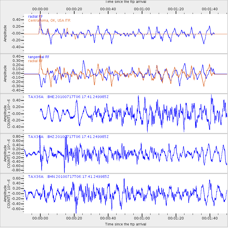
X36A Centrahoma, OK, USA - Earthquake Result Viewer
*The percent match for this event was below the threshold and hence no stack was calculated.
| Earthquake location: |
Northern Chile |
| Earthquake latitude/longitude: |
-24.7/-69.8 |
| Earthquake time(UTC): |
2010/07/17 (198) 06:07:42 GMT |
| Earthquake Depth: |
49 km |
| Earthquake Magnitude: |
5.7 MB, 5.5 MW, 5.5 MW |
| Earthquake Catalog/Contributor: |
WHDF/NEIC |
|
| Network: |
TA USArray Transportable Network (new EarthScope stations) |
| Station: |
X36A Centrahoma, OK, USA |
| Lat/Lon: |
34.57 N/96.35 W |
| Elevation: |
211 m |
|
| Distance: |
64.1 deg |
| Az: |
335.829 deg |
| Baz: |
153.176 deg |
| Ray Param: |
$rayparam |
*The percent match for this event was below the threshold and hence was not used in the summary stack. |
|
| Radial Match: |
51.649998 % |
| Radial Bump: |
400 |
| Transverse Match: |
56.696827 % |
| Transverse Bump: |
400 |
| SOD ConfigId: |
319893 |
| Insert Time: |
2011-01-05 05:12:16.662 +0000 |
| GWidth: |
2.5 |
| Max Bumps: |
400 |
| Tol: |
0.001 |
|
Signal To Noise
| Channel | StoN | STA | LTA |
| TA:X36A: :BHZ:20100717T06:17:41.249985Z | 1.7564974 | 3.1920226E-7 | 1.8172659E-7 |
| TA:X36A: :BHN:20100717T06:17:41.249985Z | 1.2418903 | 1.6341174E-7 | 1.3158308E-7 |
| TA:X36A: :BHE:20100717T06:17:41.249985Z | 0.7147939 | 1.07980185E-7 | 1.5106478E-7 |
| Arrivals |
| Ps | |
| PpPs | |
| PsPs/PpSs | |


