You are here: Home > Network List > TA - USArray Transportable Network (new EarthScope stations) Stations List
> Station Q34A Chapman, KS, USA > Earthquake Result Viewer
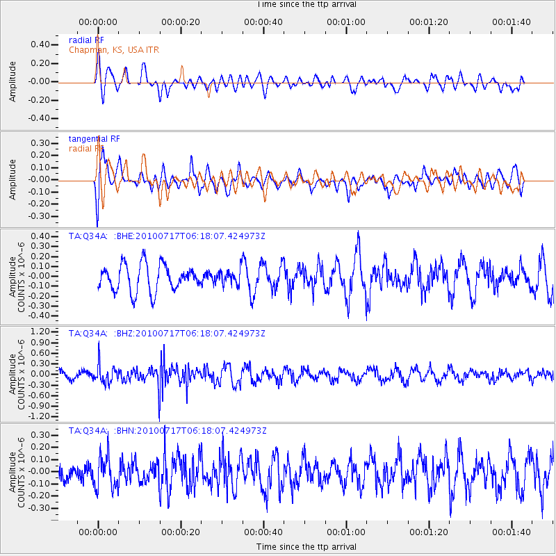
Q34A Chapman, KS, USA - Earthquake Result Viewer
*The percent match for this event was below the threshold and hence no stack was calculated.
| Earthquake location: |
Northern Chile |
| Earthquake latitude/longitude: |
-24.7/-69.8 |
| Earthquake time(UTC): |
2010/07/17 (198) 06:07:42 GMT |
| Earthquake Depth: |
49 km |
| Earthquake Magnitude: |
5.7 MB, 5.5 MW, 5.5 MW |
| Earthquake Catalog/Contributor: |
WHDF/NEIC |
|
| Network: |
TA USArray Transportable Network (new EarthScope stations) |
| Station: |
Q34A Chapman, KS, USA |
| Lat/Lon: |
38.92 N/96.94 W |
| Elevation: |
378 m |
|
| Distance: |
68.2 deg |
| Az: |
337.497 deg |
| Baz: |
153.5 deg |
| Ray Param: |
$rayparam |
*The percent match for this event was below the threshold and hence was not used in the summary stack. |
|
| Radial Match: |
44.43638 % |
| Radial Bump: |
400 |
| Transverse Match: |
51.11777 % |
| Transverse Bump: |
400 |
| SOD ConfigId: |
319893 |
| Insert Time: |
2011-01-05 05:13:30.995 +0000 |
| GWidth: |
2.5 |
| Max Bumps: |
400 |
| Tol: |
0.001 |
|
Signal To Noise
| Channel | StoN | STA | LTA |
| TA:Q34A: :BHZ:20100717T06:18:07.424973Z | 1.9976144 | 2.6227863E-7 | 1.3129592E-7 |
| TA:Q34A: :BHN:20100717T06:18:07.424973Z | 1.2232845 | 1.3654432E-7 | 1.1162107E-7 |
| TA:Q34A: :BHE:20100717T06:18:07.424973Z | 0.5781826 | 7.803234E-8 | 1.3496143E-7 |
| Arrivals |
| Ps | |
| PpPs | |
| PsPs/PpSs | |


