You are here: Home > Network List > TA - USArray Transportable Network (new EarthScope stations) Stations List
> Station V37A Hulbert, OK, USA > Earthquake Result Viewer
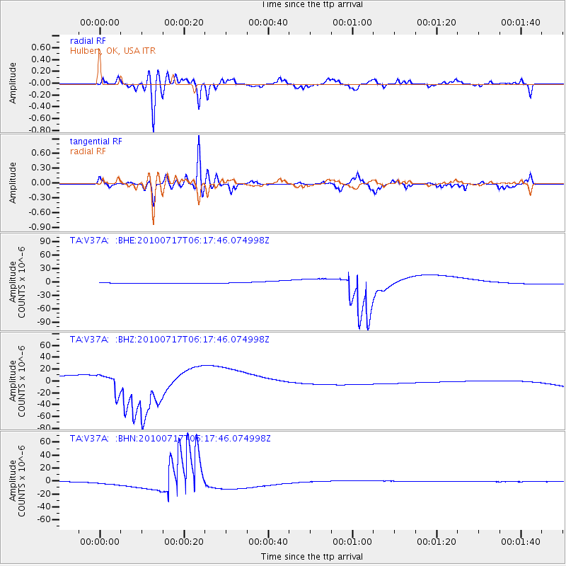
V37A Hulbert, OK, USA - Earthquake Result Viewer
*The percent match for this event was below the threshold and hence no stack was calculated.
| Earthquake location: |
Northern Chile |
| Earthquake latitude/longitude: |
-24.7/-69.8 |
| Earthquake time(UTC): |
2010/07/17 (198) 06:07:42 GMT |
| Earthquake Depth: |
49 km |
| Earthquake Magnitude: |
5.7 MB, 5.5 MW, 5.5 MW |
| Earthquake Catalog/Contributor: |
WHDF/NEIC |
|
| Network: |
TA USArray Transportable Network (new EarthScope stations) |
| Station: |
V37A Hulbert, OK, USA |
| Lat/Lon: |
35.88 N/95.14 W |
| Elevation: |
219 m |
|
| Distance: |
64.9 deg |
| Az: |
337.454 deg |
| Baz: |
154.572 deg |
| Ray Param: |
$rayparam |
*The percent match for this event was below the threshold and hence was not used in the summary stack. |
|
| Radial Match: |
76.68339 % |
| Radial Bump: |
400 |
| Transverse Match: |
86.042755 % |
| Transverse Bump: |
400 |
| SOD ConfigId: |
319893 |
| Insert Time: |
2011-01-05 05:15:22.099 +0000 |
| GWidth: |
2.5 |
| Max Bumps: |
400 |
| Tol: |
0.001 |
|
Signal To Noise
| Channel | StoN | STA | LTA |
| TA:V37A: :BHZ:20100717T06:17:46.074998Z | 1.3477014 | 1.6314094E-5 | 1.2105124E-5 |
| TA:V37A: :BHN:20100717T06:17:46.074998Z | 15.174155 | 4.1999065E-6 | 2.7678024E-7 |
| TA:V37A: :BHE:20100717T06:17:46.074998Z | 2.558325 | 1.1386749E-6 | 4.4508607E-7 |
| Arrivals |
| Ps | |
| PpPs | |
| PsPs/PpSs | |


