You are here: Home > Network List > TA - USArray Transportable Network (new EarthScope stations) Stations List
> Station V38A Canehill, AR, USA > Earthquake Result Viewer
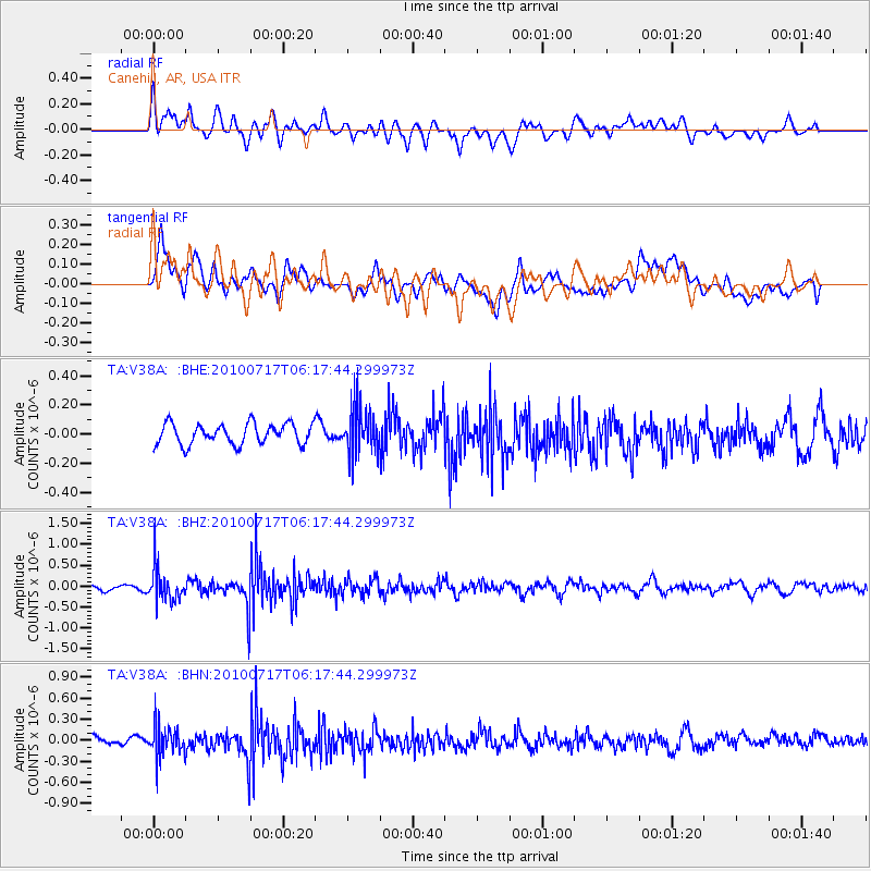
V38A Canehill, AR, USA - Earthquake Result Viewer
*The percent match for this event was below the threshold and hence no stack was calculated.
| Earthquake location: |
Northern Chile |
| Earthquake latitude/longitude: |
-24.7/-69.8 |
| Earthquake time(UTC): |
2010/07/17 (198) 06:07:42 GMT |
| Earthquake Depth: |
49 km |
| Earthquake Magnitude: |
5.7 MB, 5.5 MW, 5.5 MW |
| Earthquake Catalog/Contributor: |
WHDF/NEIC |
|
| Network: |
TA USArray Transportable Network (new EarthScope stations) |
| Station: |
V38A Canehill, AR, USA |
| Lat/Lon: |
35.86 N/94.41 W |
| Elevation: |
372 m |
|
| Distance: |
64.6 deg |
| Az: |
338.041 deg |
| Baz: |
155.25 deg |
| Ray Param: |
$rayparam |
*The percent match for this event was below the threshold and hence was not used in the summary stack. |
|
| Radial Match: |
55.499622 % |
| Radial Bump: |
400 |
| Transverse Match: |
50.98542 % |
| Transverse Bump: |
400 |
| SOD ConfigId: |
319893 |
| Insert Time: |
2011-01-05 05:15:34.708 +0000 |
| GWidth: |
2.5 |
| Max Bumps: |
400 |
| Tol: |
0.001 |
|
Signal To Noise
| Channel | StoN | STA | LTA |
| TA:V38A: :BHZ:20100717T06:17:44.299973Z | 6.659776 | 3.9251336E-7 | 5.893792E-8 |
| TA:V38A: :BHN:20100717T06:17:44.299973Z | 4.7881355 | 2.1937363E-7 | 4.5816083E-8 |
| TA:V38A: :BHE:20100717T06:17:44.299973Z | 2.220576 | 1.5641326E-7 | 7.043815E-8 |
| Arrivals |
| Ps | |
| PpPs | |
| PsPs/PpSs | |


