You are here: Home > Network List > N4 - Central and EAstern US Network Stations List
> Station L59A Walton, NY, USA > Earthquake Result Viewer
L59A Walton, NY, USA - Earthquake Result Viewer
| Earthquake location: |
Near Coast Of Jalisco, Mexico |
| Earthquake latitude/longitude: |
19.3/-105.1 |
| Earthquake time(UTC): |
2023/09/08 (251) 15:53:17 GMT |
| Earthquake Depth: |
5.4 km |
| Earthquake Magnitude: |
5.6 mww |
| Earthquake Catalog/Contributor: |
NEIC PDE/us |
|
| Network: |
N4 Central and EAstern US Network |
| Station: |
L59A Walton, NY, USA |
| Lat/Lon: |
42.19 N/75.04 W |
| Elevation: |
677 m |
|
| Distance: |
34.2 deg |
| Az: |
41.543 deg |
| Baz: |
237.435 deg |
| Ray Param: |
0.07787891 |
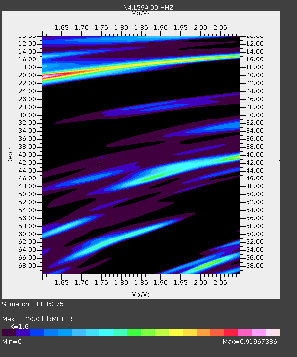
| Estimated Moho Depth: |
20.0 km |
| Estimated Crust Vp/Vs: |
1.60 |
| Assumed Crust Vp: |
6.419 km/s |
| Estimated Crust Vs: |
4.012 km/s |
| Estimated Crust Poisson's Ratio: |
0.18 |
|
| Radial Match: |
83.86375 % |
| Radial Bump: |
400 |
| Transverse Match: |
42.18082 % |
| Transverse Bump: |
400 |
| SOD ConfigId: |
31937991 |
| Insert Time: |
2023-09-22 16:08:30.834 +0000 |
| GWidth: |
2.5 |
| Max Bumps: |
400 |
| Tol: |
0.001 |
|

Signal To Noise
| Channel | StoN | STA | LTA |
| N4:L59A:00:HHZ:20230908T15:59:32.568991Z | 2.1610675 | 2.97838E-7 | 1.3781985E-7 |
| N4:L59A:00:HH1:20230908T15:59:32.568991Z | 0.9883308 | 1.5726783E-7 | 1.591247E-7 |
| N4:L59A:00:HH2:20230908T15:59:32.568991Z | 1.2718477 | 1.7315371E-7 | 1.3614343E-7 |
| Arrivals |
| Ps | 2.0 SECOND |
| PpPs | 7.4 SECOND |
| PsPs/PpSs | 9.5 SECOND |


