You are here: Home > Network List > UW - Pacific Northwest Regional Seismic Network Stations List
> Station CDF Cedar Flats, MSH, WA, USA > Earthquake Result Viewer
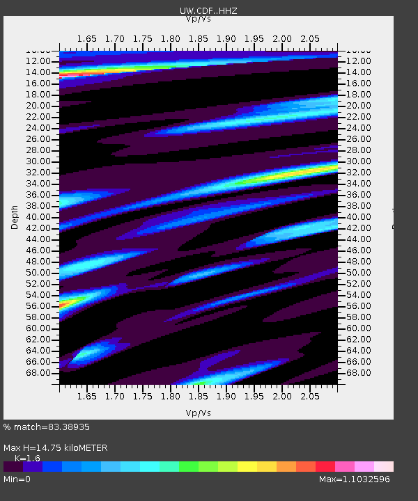
CDF Cedar Flats, MSH, WA, USA - Earthquake Result Viewer
| Earthquake location: |
Near Coast Of Jalisco, Mexico |
| Earthquake latitude/longitude: |
19.3/-105.1 |
| Earthquake time(UTC): |
2023/09/08 (251) 15:53:17 GMT |
| Earthquake Depth: |
5.4 km |
| Earthquake Magnitude: |
5.6 mww |
| Earthquake Catalog/Contributor: |
NEIC PDE/us |
|
| Network: |
UW Pacific Northwest Regional Seismic Network |
| Station: |
CDF Cedar Flats, MSH, WA, USA |
| Lat/Lon: |
46.12 N/122.05 W |
| Elevation: |
772 m |
|
| Distance: |
30.2 deg |
| Az: |
336.247 deg |
| Baz: |
146.846 deg |
| Ray Param: |
0.0795081 |
| Estimated Moho Depth: |
14.75 km |
| Estimated Crust Vp/Vs: |
1.60 |
| Assumed Crust Vp: |
6.566 km/s |
| Estimated Crust Vs: |
4.104 km/s |
| Estimated Crust Poisson's Ratio: |
0.18 |
|
| Radial Match: |
83.38935 % |
| Radial Bump: |
400 |
| Transverse Match: |
65.702995 % |
| Transverse Bump: |
400 |
| SOD ConfigId: |
31937991 |
| Insert Time: |
2023-09-22 16:12:09.304 +0000 |
| GWidth: |
2.5 |
| Max Bumps: |
400 |
| Tol: |
0.001 |
|

Signal To Noise
| Channel | StoN | STA | LTA |
| UW:CDF: :HHZ:20230908T15:58:57.260001Z | 6.928644 | 4.7271175E-7 | 6.8225724E-8 |
| UW:CDF: :HHN:20230908T15:58:57.260001Z | 2.9627411 | 2.7695071E-7 | 9.3477865E-8 |
| UW:CDF: :HHE:20230908T15:58:57.260001Z | 1.0347008 | 1.1494898E-7 | 1.1109393E-7 |
| Arrivals |
| Ps | 1.5 SECOND |
| PpPs | 5.3 SECOND |
| PsPs/PpSs | 6.8 SECOND |


