You are here: Home > Network List > UW - Pacific Northwest Regional Seismic Network Stations List
> Station WAT2 Waterville, WA, USA > Earthquake Result Viewer
WAT2 Waterville, WA, USA - Earthquake Result Viewer
| Earthquake location: |
Near Coast Of Jalisco, Mexico |
| Earthquake latitude/longitude: |
19.3/-105.1 |
| Earthquake time(UTC): |
2023/09/08 (251) 15:53:17 GMT |
| Earthquake Depth: |
5.4 km |
| Earthquake Magnitude: |
5.6 mww |
| Earthquake Catalog/Contributor: |
NEIC PDE/us |
|
| Network: |
UW Pacific Northwest Regional Seismic Network |
| Station: |
WAT2 Waterville, WA, USA |
| Lat/Lon: |
47.62 N/120.11 W |
| Elevation: |
875 m |
|
| Distance: |
30.8 deg |
| Az: |
340.013 deg |
| Baz: |
151.498 deg |
| Ray Param: |
0.07932582 |
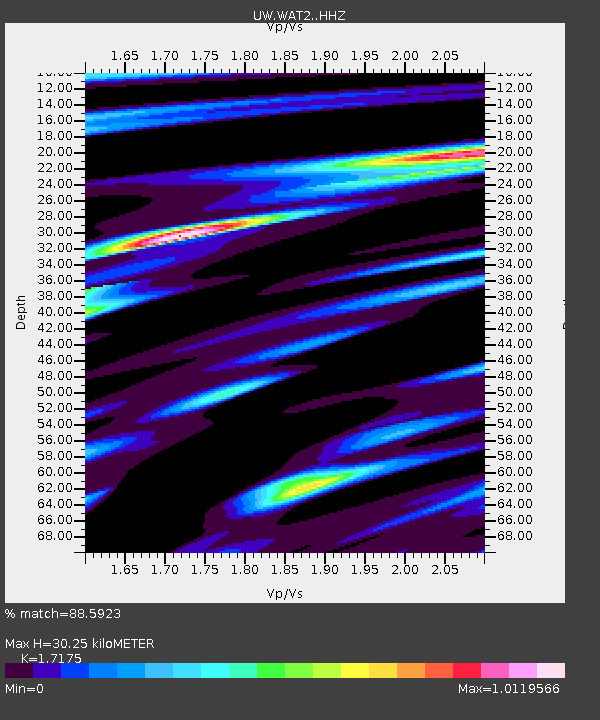
| Estimated Moho Depth: |
30.25 km |
| Estimated Crust Vp/Vs: |
1.72 |
| Assumed Crust Vp: |
6.597 km/s |
| Estimated Crust Vs: |
3.841 km/s |
| Estimated Crust Poisson's Ratio: |
0.24 |
|
| Radial Match: |
88.5923 % |
| Radial Bump: |
327 |
| Transverse Match: |
62.98316 % |
| Transverse Bump: |
400 |
| SOD ConfigId: |
31937991 |
| Insert Time: |
2023-09-22 16:14:16.088 +0000 |
| GWidth: |
2.5 |
| Max Bumps: |
400 |
| Tol: |
0.001 |
|

Signal To Noise
| Channel | StoN | STA | LTA |
| UW:WAT2: :HHZ:20230908T15:59:02.659995Z | 8.501263 | 6.3494485E-7 | 7.46883E-8 |
| UW:WAT2: :HHN:20230908T15:59:02.659995Z | 4.5542727 | 3.746304E-7 | 8.2259106E-8 |
| UW:WAT2: :HHE:20230908T15:59:02.659995Z | 3.2433732 | 2.4925873E-7 | 7.685169E-8 |
| Arrivals |
| Ps | 3.6 SECOND |
| PpPs | 11 SECOND |
| PsPs/PpSs | 15 SECOND |


