You are here: Home > Network List > UW - Pacific Northwest Regional Seismic Network Stations List
> Station YACT Yacolt, WA, USA > Earthquake Result Viewer
YACT Yacolt, WA, USA - Earthquake Result Viewer
| Earthquake location: |
Near Coast Of Jalisco, Mexico |
| Earthquake latitude/longitude: |
19.3/-105.1 |
| Earthquake time(UTC): |
2023/09/08 (251) 15:53:17 GMT |
| Earthquake Depth: |
5.4 km |
| Earthquake Magnitude: |
5.6 mww |
| Earthquake Catalog/Contributor: |
NEIC PDE/us |
|
| Network: |
UW Pacific Northwest Regional Seismic Network |
| Station: |
YACT Yacolt, WA, USA |
| Lat/Lon: |
45.93 N/122.42 W |
| Elevation: |
214 m |
|
| Distance: |
30.1 deg |
| Az: |
335.612 deg |
| Baz: |
146.03 deg |
| Ray Param: |
0.07951075 |
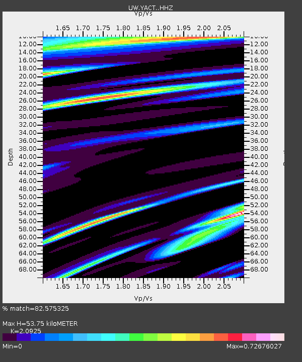
| Estimated Moho Depth: |
53.75 km |
| Estimated Crust Vp/Vs: |
2.09 |
| Assumed Crust Vp: |
6.566 km/s |
| Estimated Crust Vs: |
3.138 km/s |
| Estimated Crust Poisson's Ratio: |
0.35 |
|
| Radial Match: |
82.575325 % |
| Radial Bump: |
400 |
| Transverse Match: |
61.036285 % |
| Transverse Bump: |
400 |
| SOD ConfigId: |
31937991 |
| Insert Time: |
2023-09-22 16:14:26.994 +0000 |
| GWidth: |
2.5 |
| Max Bumps: |
400 |
| Tol: |
0.001 |
|

Signal To Noise
| Channel | StoN | STA | LTA |
| UW:YACT: :HHZ:20230908T15:58:57.170004Z | 3.3103426 | 3.8271085E-7 | 1.1561065E-7 |
| UW:YACT: :HHN:20230908T15:58:57.170004Z | 2.245633 | 2.2779555E-7 | 1.01439355E-7 |
| UW:YACT: :HHE:20230908T15:58:57.170004Z | 2.1530566 | 1.7590182E-7 | 8.169865E-8 |
| Arrivals |
| Ps | 9.6 SECOND |
| PpPs | 24 SECOND |
| PsPs/PpSs | 33 SECOND |


