You are here: Home > Network List > AK - Alaska Regional Network Stations List
> Station C21K Knifeblade Ridge, AK, USA > Earthquake Result Viewer
C21K Knifeblade Ridge, AK, USA - Earthquake Result Viewer
| Earthquake location: |
Near Coast Of Jalisco, Mexico |
| Earthquake latitude/longitude: |
19.5/-104.9 |
| Earthquake time(UTC): |
2023/09/08 (251) 16:37:17 GMT |
| Earthquake Depth: |
45 km |
| Earthquake Magnitude: |
5.7 mww |
| Earthquake Catalog/Contributor: |
NEIC PDE/us |
|
| Network: |
AK Alaska Regional Network |
| Station: |
C21K Knifeblade Ridge, AK, USA |
| Lat/Lon: |
69.16 N/154.78 W |
| Elevation: |
409 m |
|
| Distance: |
58.2 deg |
| Az: |
341.192 deg |
| Baz: |
121.828 deg |
| Ray Param: |
0.06292233 |
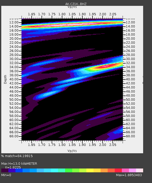
| Estimated Moho Depth: |
13.0 km |
| Estimated Crust Vp/Vs: |
1.82 |
| Assumed Crust Vp: |
6.221 km/s |
| Estimated Crust Vs: |
3.413 km/s |
| Estimated Crust Poisson's Ratio: |
0.28 |
|
| Radial Match: |
84.19915 % |
| Radial Bump: |
400 |
| Transverse Match: |
67.59841 % |
| Transverse Bump: |
400 |
| SOD ConfigId: |
31937991 |
| Insert Time: |
2023-09-22 16:39:03.857 +0000 |
| GWidth: |
2.5 |
| Max Bumps: |
400 |
| Tol: |
0.001 |
|

Signal To Noise
| Channel | StoN | STA | LTA |
| AK:C21K: :BHZ:20230908T16:46:35.859985Z | 10.764909 | 2.9876574E-6 | 2.775367E-7 |
| AK:C21K: :BHN:20230908T16:46:35.859985Z | 1.4729918 | 4.970593E-7 | 3.374488E-7 |
| AK:C21K: :BHE:20230908T16:46:35.859985Z | 4.13728 | 8.915722E-7 | 2.154972E-7 |
| Arrivals |
| Ps | 1.8 SECOND |
| PpPs | 5.6 SECOND |
| PsPs/PpSs | 7.4 SECOND |


