You are here: Home > Network List > AZ - ANZA Regional Network Stations List
> Station MONP2 Monument Peak TA Vault, Mt. Laguna, CA, USA > Earthquake Result Viewer
MONP2 Monument Peak TA Vault, Mt. Laguna, CA, USA - Earthquake Result Viewer
| Earthquake location: |
Fox Islands, Aleutian Islands |
| Earthquake latitude/longitude: |
52.9/-169.8 |
| Earthquake time(UTC): |
2010/07/18 (199) 05:56:44 GMT |
| Earthquake Depth: |
14 km |
| Earthquake Magnitude: |
6.3 MB, 6.7 MS, 6.6 MW, 6.6 MW |
| Earthquake Catalog/Contributor: |
WHDF/NEIC |
|
| Network: |
AZ ANZA Regional Network |
| Station: |
MONP2 Monument Peak TA Vault, Mt. Laguna, CA, USA |
| Lat/Lon: |
32.89 N/116.42 W |
| Elevation: |
1000 m |
|
| Distance: |
42.8 deg |
| Az: |
96.011 deg |
| Baz: |
314.238 deg |
| Ray Param: |
0.072948545 |
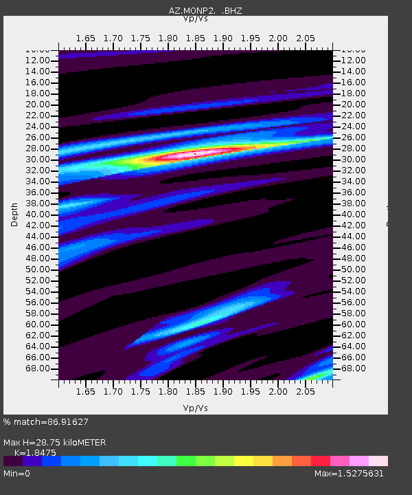
| Estimated Moho Depth: |
28.75 km |
| Estimated Crust Vp/Vs: |
1.85 |
| Assumed Crust Vp: |
6.264 km/s |
| Estimated Crust Vs: |
3.39 km/s |
| Estimated Crust Poisson's Ratio: |
0.29 |
|
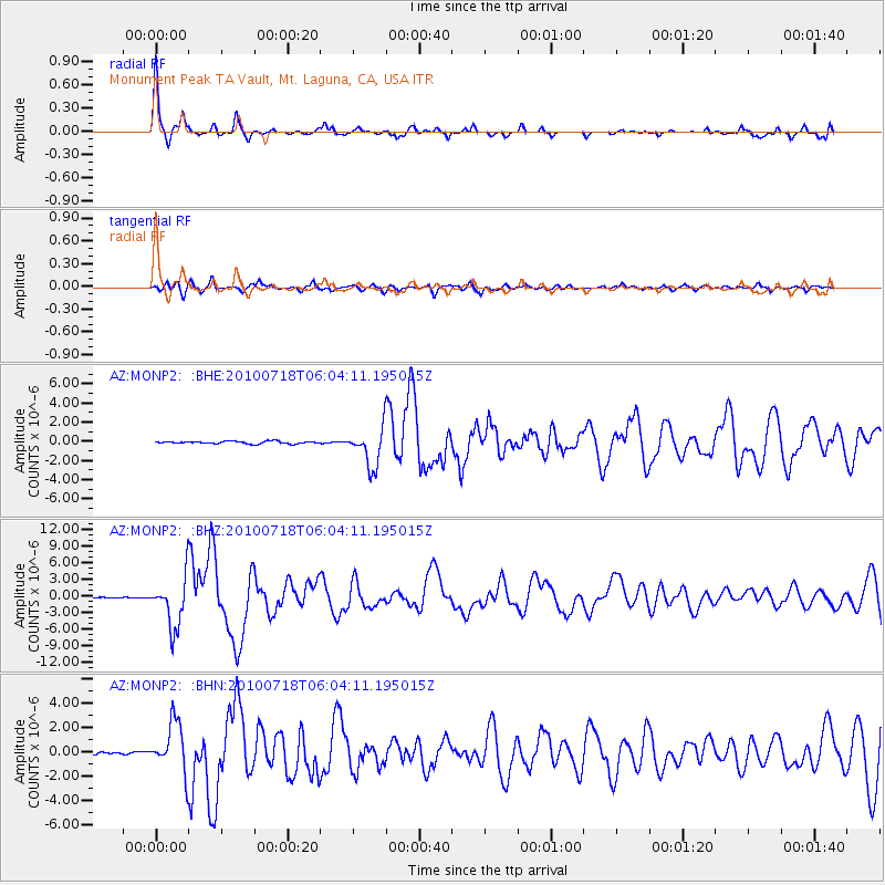
| Radial Match: |
86.91627 % |
| Radial Bump: |
312 |
| Transverse Match: |
64.07309 % |
| Transverse Bump: |
400 |
| SOD ConfigId: |
319893 |
| Insert Time: |
2011-01-05 05:24:54.194 +0000 |
| GWidth: |
2.5 |
| Max Bumps: |
400 |
| Tol: |
0.001 |
|
Signal To Noise
| Channel | StoN | STA | LTA |
| AZ:MONP2: :BHZ:20100718T06:04:11.195015Z | 32.814266 | 4.470516E-6 | 1.3623698E-7 |
| AZ:MONP2: :BHN:20100718T06:04:11.195015Z | 13.68497 | 2.0263426E-6 | 1.4807067E-7 |
| AZ:MONP2: :BHE:20100718T06:04:11.195015Z | 16.040155 | 2.029009E-6 | 1.2649559E-7 |
| Arrivals |
| Ps | 4.1 SECOND |
| PpPs | 12 SECOND |
| PsPs/PpSs | 16 SECOND |


