You are here: Home > Network List > US - United States National Seismic Network Stations List
> Station MSO Missoula, Montana, USA > Earthquake Result Viewer
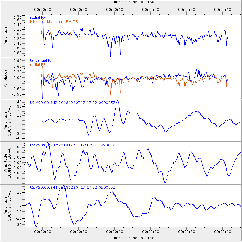
MSO Missoula, Montana, USA - Earthquake Result Viewer
*The percent match for this event was below the threshold and hence no stack was calculated.
| Earthquake location: |
Komandorskiye Ostrova Region |
| Earthquake latitude/longitude: |
54.9/164.8 |
| Earthquake time(UTC): |
2018/12/20 (354) 17:09:04 GMT |
| Earthquake Depth: |
10 km |
| Earthquake Magnitude: |
5.9 mb |
| Earthquake Catalog/Contributor: |
NEIC PDE/us |
|
| Network: |
US United States National Seismic Network |
| Station: |
MSO Missoula, Montana, USA |
| Lat/Lon: |
46.83 N/113.94 W |
| Elevation: |
1264 m |
|
| Distance: |
49.2 deg |
| Az: |
63.728 deg |
| Baz: |
311.034 deg |
| Ray Param: |
$rayparam |
*The percent match for this event was below the threshold and hence was not used in the summary stack. |
|
| Radial Match: |
28.394346 % |
| Radial Bump: |
400 |
| Transverse Match: |
38.746765 % |
| Transverse Bump: |
400 |
| SOD ConfigId: |
3201911 |
| Insert Time: |
2019-01-15 01:41:19.574 +0000 |
| GWidth: |
2.5 |
| Max Bumps: |
400 |
| Tol: |
0.001 |
|
Signal To Noise
| Channel | StoN | STA | LTA |
| US:MSO:00:BHZ:20181220T17:17:22.099005Z | 3.2861733 | 7.5627936E-6 | 2.3013984E-6 |
| US:MSO:00:BH1:20181220T17:17:22.099005Z | 3.3191917 | 8.813705E-6 | 2.6553769E-6 |
| US:MSO:00:BH2:20181220T17:17:22.099005Z | 2.6325777 | 1.1404592E-5 | 4.332101E-6 |
| Arrivals |
| Ps | |
| PpPs | |
| PsPs/PpSs | |


