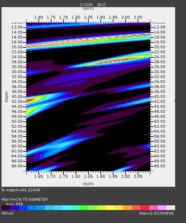
DGR Domenigoni Reservoir, California, USA - Earthquake Result Viewer
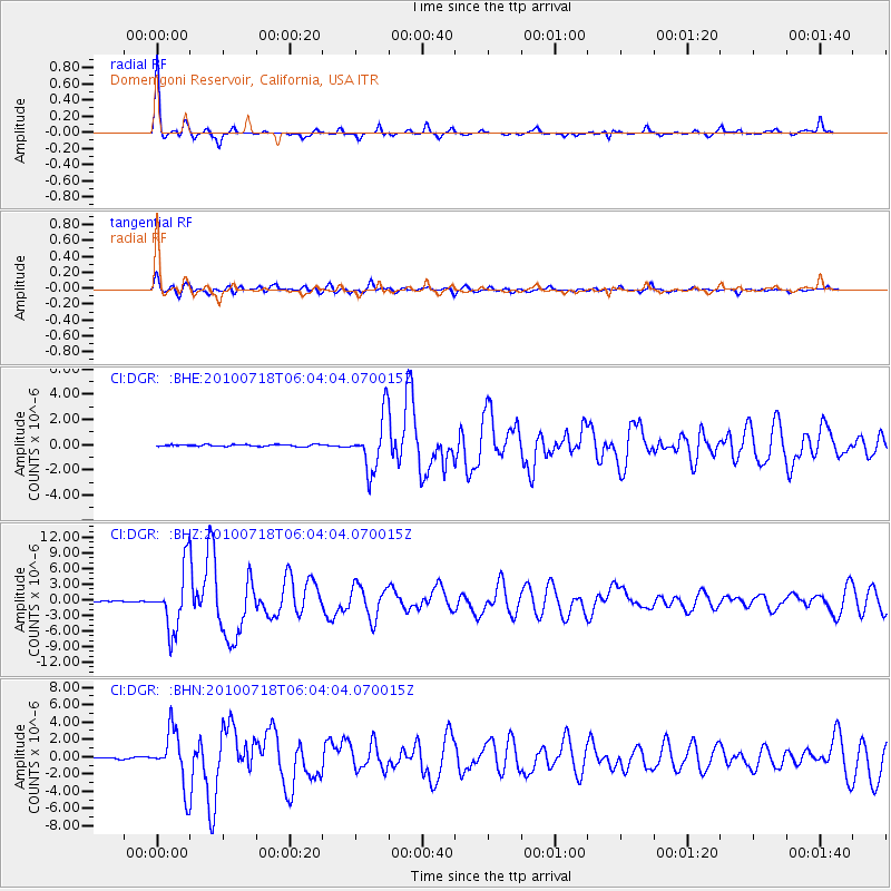
Earthquake location: Fox Islands, Aleutian Islands
Earthquake latitude/longitude: 52.9/-169.8
Earthquake time(UTC): 2010/07/18 (199) 05:56:44 GMT
Earthquake Depth: 14 km
Earthquake Magnitude: 6.3 MB, 6.7 MS, 6.6 MW, 6.6 MW
Earthquake Catalog/Contributor: WHDF/NEIC
Network: CI Caltech Regional Seismic Network
Station: DGR Domenigoni Reservoir, California, USA
Lat/Lon: 33.65 N/117.01 W
Elevation: 609 m
Distance: 41.9 deg
Az: 95.71 deg
Baz: 313.695 deg
Ray Param: 0.07347543
Estimated Moho Depth: 16.75 km
Estimated Crust Vp/Vs: 1.85
Assumed Crust Vp: 6.264 km/s
Estimated Crust Vs: 3.395 km/s
Estimated Crust Poisson's Ratio: 0.29
Radial Match: 94.31849 %
Radial Bump: 258
Transverse Match: 85.00587 %
Transverse Bump: 400
SOD ConfigId: 319893
Insert Time: 2011-01-05 05:27:04.965 +0000
GWidth: 2.5
Max Bumps: 400
Tol: 0.001

Signal To Noise

ChannelStoNSTALTA
CI:DGR: :BHZ:20100718T06:04:04.070015Z63.703755.896878E-69.2567205E-8
CI:DGR: :BHN:20100718T06:04:04.070015Z42.762013.1966451E-67.4754325E-8
CI:DGR: :BHE:20100718T06:04:04.070015Z29.4731772.1271903E-67.217377E-8
Arrivals
Ps2.4 SECOND
PpPs7.2 SECOND
PsPs/PpSs9.6 SECOND