You are here: Home > Network List > G - GEOSCOPE Stations List
> Station PPTF Pamatai - Papeete - Tahiti island - French Polynesia, France > Earthquake Result Viewer
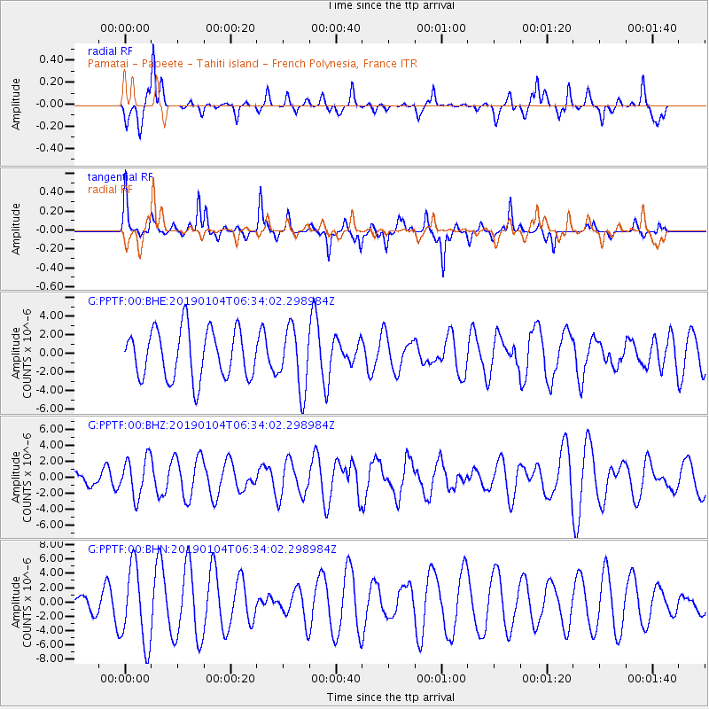
PPTF Pamatai - Papeete - Tahiti island - French Polynesia, France - Earthquake Result Viewer
*The percent match for this event was below the threshold and hence no stack was calculated.
| Earthquake location: |
Banda Sea |
| Earthquake latitude/longitude: |
-6.5/130.4 |
| Earthquake time(UTC): |
2019/01/04 (004) 06:22:44 GMT |
| Earthquake Depth: |
118 km |
| Earthquake Magnitude: |
5.6 Mww |
| Earthquake Catalog/Contributor: |
NEIC PDE/us |
|
| Network: |
G GEOSCOPE |
| Station: |
PPTF Pamatai - Papeete - Tahiti island - French Polynesia, France |
| Lat/Lon: |
17.59 S/149.57 W |
| Elevation: |
705 m |
|
| Distance: |
78.6 deg |
| Az: |
106.589 deg |
| Baz: |
266.736 deg |
| Ray Param: |
$rayparam |
*The percent match for this event was below the threshold and hence was not used in the summary stack. |
|
| Radial Match: |
52.08071 % |
| Radial Bump: |
328 |
| Transverse Match: |
49.96105 % |
| Transverse Bump: |
262 |
| SOD ConfigId: |
3201911 |
| Insert Time: |
2019-01-18 06:33:10.904 +0000 |
| GWidth: |
2.5 |
| Max Bumps: |
400 |
| Tol: |
0.001 |
|
Signal To Noise
| Channel | StoN | STA | LTA |
| G:PPTF:00:BHZ:20190104T06:34:02.298984Z | 1.831889 | 2.4743288E-6 | 1.3506979E-6 |
| G:PPTF:00:BHN:20190104T06:34:02.298984Z | 4.386723 | 5.4644884E-6 | 1.2456879E-6 |
| G:PPTF:00:BHE:20190104T06:34:02.298984Z | 1.2540249 | 3.2947935E-6 | 2.627375E-6 |
| Arrivals |
| Ps | |
| PpPs | |
| PsPs/PpSs | |


