You are here: Home > Network List > CM - Red Sismologica Nacional de Columbia Stations List
> Station SMAR Santa Marta, Magdalena, Colombia > Earthquake Result Viewer
SMAR Santa Marta, Magdalena, Colombia - Earthquake Result Viewer
| Earthquake location: |
Near Coast Of Jalisco, Mexico |
| Earthquake latitude/longitude: |
19.5/-104.9 |
| Earthquake time(UTC): |
2023/09/08 (251) 16:37:17 GMT |
| Earthquake Depth: |
45 km |
| Earthquake Magnitude: |
5.7 mww |
| Earthquake Catalog/Contributor: |
NEIC PDE/us |
|
| Network: |
CM Red Sismologica Nacional de Columbia |
| Station: |
SMAR Santa Marta, Magdalena, Colombia |
| Lat/Lon: |
11.16 N/74.22 W |
| Elevation: |
122 m |
|
| Distance: |
30.6 deg |
| Az: |
101.209 deg |
| Baz: |
289.469 deg |
| Ray Param: |
0.07929023 |
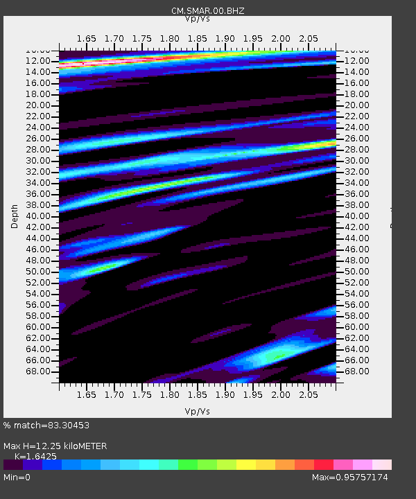
| Estimated Moho Depth: |
12.25 km |
| Estimated Crust Vp/Vs: |
1.64 |
| Assumed Crust Vp: |
5.129 km/s |
| Estimated Crust Vs: |
3.123 km/s |
| Estimated Crust Poisson's Ratio: |
0.21 |
|
| Radial Match: |
83.30453 % |
| Radial Bump: |
400 |
| Transverse Match: |
62.64437 % |
| Transverse Bump: |
400 |
| SOD ConfigId: |
31937991 |
| Insert Time: |
2023-09-22 16:48:25.381 +0000 |
| GWidth: |
2.5 |
| Max Bumps: |
400 |
| Tol: |
0.001 |
|

Signal To Noise
| Channel | StoN | STA | LTA |
| CM:SMAR:00:BHZ:20230908T16:42:57.118988Z | 9.014591 | 1.2080241E-6 | 1.3400764E-7 |
| CM:SMAR:00:BHN:20230908T16:42:57.118988Z | 2.570623 | 3.1371562E-7 | 1.2203876E-7 |
| CM:SMAR:00:BHE:20230908T16:42:57.118988Z | 2.447365 | 3.8197487E-7 | 1.5607597E-7 |
| Arrivals |
| Ps | 1.6 SECOND |
| PpPs | 6.0 SECOND |
| PsPs/PpSs | 7.6 SECOND |


