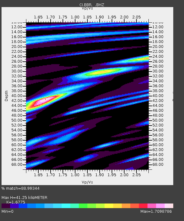
BBR Big Bear Solar Observatory - Earthquake Result Viewer

Earthquake location: Fox Islands, Aleutian Islands
Earthquake latitude/longitude: 52.9/-169.8
Earthquake time(UTC): 2010/07/18 (199) 05:56:44 GMT
Earthquake Depth: 14 km
Earthquake Magnitude: 6.3 MB, 6.7 MS, 6.6 MW, 6.6 MW
Earthquake Catalog/Contributor: WHDF/NEIC
Network: CI Caltech Regional Seismic Network
Station: BBR Big Bear Solar Observatory
Lat/Lon: 34.26 N/116.92 W
Elevation: 2069 m
Distance: 41.6 deg
Az: 94.968 deg
Baz: 313.191 deg
Ray Param: 0.07370924
Estimated Moho Depth: 41.25 km
Estimated Crust Vp/Vs: 1.68
Assumed Crust Vp: 6.276 km/s
Estimated Crust Vs: 3.741 km/s
Estimated Crust Poisson's Ratio: 0.22
Radial Match: 88.99344 %
Radial Bump: 400
Transverse Match: 69.22336 %
Transverse Bump: 400
SOD ConfigId: 319893
Insert Time: 2011-01-05 05:28:51.709 +0000
GWidth: 2.5
Max Bumps: 400
Tol: 0.001

Signal To Noise

ChannelStoNSTALTA
CI:BBR: :BHZ:20100718T06:04:01.070015Z38.080724.886442E-61.28318E-7
CI:BBR: :BHN:20100718T06:04:01.070015Z22.9373532.5061727E-61.09261634E-7
CI:BBR: :BHE:20100718T06:04:01.070015Z23.0814172.5682803E-61.11270474E-7
Arrivals
Ps4.8 SECOND
PpPs16 SECOND
PsPs/PpSs21 SECOND