You are here: Home > Network List > LD - Lamont-Doherty Cooperative Seismographic Network Stations List
> Station GEDE Greenville, DE, USA > Earthquake Result Viewer
GEDE Greenville, DE, USA - Earthquake Result Viewer
| Earthquake location: |
Near Coast Of Jalisco, Mexico |
| Earthquake latitude/longitude: |
19.5/-104.9 |
| Earthquake time(UTC): |
2023/09/08 (251) 16:37:17 GMT |
| Earthquake Depth: |
45 km |
| Earthquake Magnitude: |
5.7 mww |
| Earthquake Catalog/Contributor: |
NEIC PDE/us |
|
| Network: |
LD Lamont-Doherty Cooperative Seismographic Network |
| Station: |
GEDE Greenville, DE, USA |
| Lat/Lon: |
39.81 N/75.64 W |
| Elevation: |
105 m |
|
| Distance: |
32.2 deg |
| Az: |
44.833 deg |
| Baz: |
239.694 deg |
| Ray Param: |
0.07866926 |
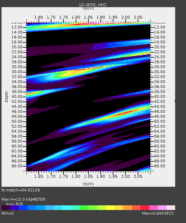
| Estimated Moho Depth: |
10.0 km |
| Estimated Crust Vp/Vs: |
1.92 |
| Assumed Crust Vp: |
6.287 km/s |
| Estimated Crust Vs: |
3.266 km/s |
| Estimated Crust Poisson's Ratio: |
0.32 |
|
| Radial Match: |
84.82185 % |
| Radial Bump: |
400 |
| Transverse Match: |
45.003853 % |
| Transverse Bump: |
400 |
| SOD ConfigId: |
31937991 |
| Insert Time: |
2023-09-22 16:54:53.074 +0000 |
| GWidth: |
2.5 |
| Max Bumps: |
400 |
| Tol: |
0.001 |
|
Signal To Noise
| Channel | StoN | STA | LTA |
| LD:GEDE: :HHZ:20230908T16:43:10.98001Z | 2.5583193 | 9.0294736E-7 | 3.529455E-7 |
| LD:GEDE: :HHN:20230908T16:43:10.98001Z | 1.5874768 | 3.5977516E-7 | 2.2663332E-7 |
| LD:GEDE: :HHE:20230908T16:43:10.98001Z | 3.1809666 | 4.609256E-7 | 1.4490112E-7 |
| Arrivals |
| Ps | 1.6 SECOND |
| PpPs | 4.3 SECOND |
| PsPs/PpSs | 5.9 SECOND |


