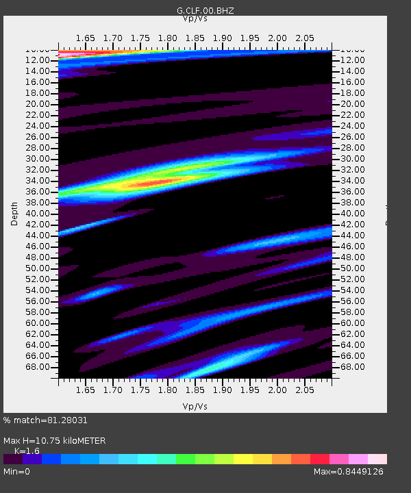
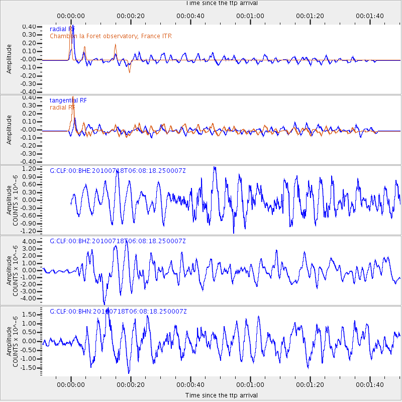
CLF Chambon la Foret observatory, France - Earthquake Result Viewer

Earthquake location: Fox Islands, Aleutian Islands
Earthquake latitude/longitude: 52.9/-169.8
Earthquake time(UTC): 2010/07/18 (199) 05:56:44 GMT
Earthquake Depth: 14 km
Earthquake Magnitude: 6.3 MB, 6.7 MS, 6.6 MW, 6.6 MW
Earthquake Catalog/Contributor: WHDF/NEIC
Network: G GEOSCOPE
Station: CLF Chambon la Foret observatory, France
Lat/Lon: 48.03 N/2.26 E
Elevation: 145 m
Distance: 79.3 deg
Az: 5.383 deg
Baz: 355.141 deg
Ray Param: 0.04908211
Estimated Moho Depth: 10.75 km
Estimated Crust Vp/Vs: 1.60
Assumed Crust Vp: 6.12 km/s
Estimated Crust Vs: 3.825 km/s
Estimated Crust Poisson's Ratio: 0.18
Radial Match: 81.28031 %
Radial Bump: 400
Transverse Match: 70.1104 %
Transverse Bump: 400
SOD ConfigId: 319893
Insert Time: 2011-01-05 05:31:05.902 +0000
GWidth: 2.5
Max Bumps: 400
Tol: 0.001

Signal To Noise

ChannelStoNSTALTA
G:CLF:00:BHZ:20100718T06:08:18.250007Z1.87483615.257373E-72.804177E-7
G:CLF:00:BHN:20100718T06:08:18.250007Z0.85121432.58043E-73.0314695E-7
G:CLF:00:BHE:20100718T06:08:18.250007Z0.976695364.5648807E-74.6738018E-7
Arrivals
Ps1.1 SECOND
PpPs4.4 SECOND
PsPs/PpSs5.5 SECOND