You are here: Home > Network List > UW - Pacific Northwest Regional Seismic Network Stations List
> Station NEMA NEMA Site, Pacific County, WA, USA > Earthquake Result Viewer
NEMA NEMA Site, Pacific County, WA, USA - Earthquake Result Viewer
| Earthquake location: |
Near Coast Of Jalisco, Mexico |
| Earthquake latitude/longitude: |
19.5/-104.9 |
| Earthquake time(UTC): |
2023/09/08 (251) 16:37:17 GMT |
| Earthquake Depth: |
45 km |
| Earthquake Magnitude: |
5.7 mww |
| Earthquake Catalog/Contributor: |
NEIC PDE/us |
|
| Network: |
UW Pacific Northwest Regional Seismic Network |
| Station: |
NEMA NEMA Site, Pacific County, WA, USA |
| Lat/Lon: |
46.50 N/123.75 W |
| Elevation: |
509 m |
|
| Distance: |
31.1 deg |
| Az: |
334.297 deg |
| Baz: |
143.69 deg |
| Ray Param: |
0.07914176 |
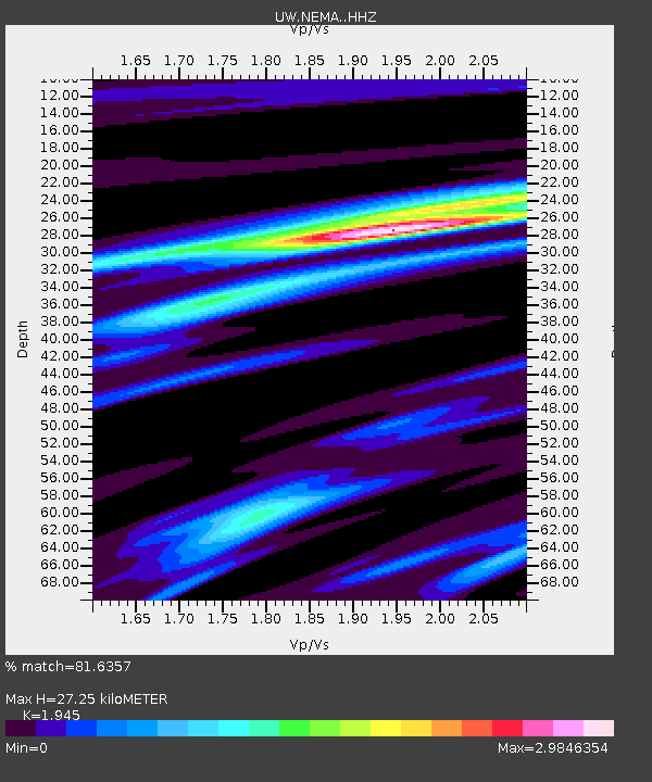
| Estimated Moho Depth: |
27.25 km |
| Estimated Crust Vp/Vs: |
1.95 |
| Assumed Crust Vp: |
6.566 km/s |
| Estimated Crust Vs: |
3.376 km/s |
| Estimated Crust Poisson's Ratio: |
0.32 |
|
| Radial Match: |
81.6357 % |
| Radial Bump: |
246 |
| Transverse Match: |
65.13551 % |
| Transverse Bump: |
400 |
| SOD ConfigId: |
31937991 |
| Insert Time: |
2023-09-22 17:01:12.739 +0000 |
| GWidth: |
2.5 |
| Max Bumps: |
400 |
| Tol: |
0.001 |
|

Signal To Noise
| Channel | StoN | STA | LTA |
| UW:NEMA: :HHZ:20230908T16:43:00.73001Z | 9.400465 | 2.08661E-6 | 2.2196882E-7 |
| UW:NEMA: :HHN:20230908T16:43:00.73001Z | 3.8948488 | 1.0062628E-6 | 2.5835732E-7 |
| UW:NEMA: :HHE:20230908T16:43:00.73001Z | 4.5688715 | 8.2271305E-7 | 1.8006921E-7 |
| Arrivals |
| Ps | 4.2 SECOND |
| PpPs | 11 SECOND |
| PsPs/PpSs | 16 SECOND |


