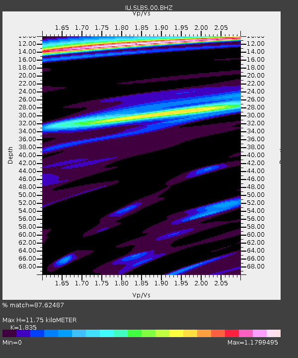
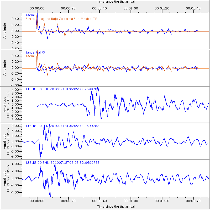
SLBS Sierra la Laguna Baja California Sur, Mexico - Earthquake Result Viewer

Earthquake location: Fox Islands, Aleutian Islands
Earthquake latitude/longitude: 52.9/-169.8
Earthquake time(UTC): 2010/07/18 (199) 05:56:44 GMT
Earthquake Depth: 14 km
Earthquake Magnitude: 6.3 MB, 6.7 MS, 6.6 MW, 6.6 MW
Earthquake Catalog/Contributor: WHDF/NEIC
Network: IU Global Seismograph Network (GSN - IRIS/USGS)
Station: SLBS Sierra la Laguna Baja California Sur, Mexico
Lat/Lon: 23.69 N/109.94 W
Elevation: 825 m
Distance: 53.4 deg
Az: 98.852 deg
Baz: 319.21 deg
Ray Param: 0.06612188
Estimated Moho Depth: 11.75 km
Estimated Crust Vp/Vs: 1.84
Assumed Crust Vp: 6.183 km/s
Estimated Crust Vs: 3.369 km/s
Estimated Crust Poisson's Ratio: 0.29
Radial Match: 87.62487 %
Radial Bump: 400
Transverse Match: 84.958374 %
Transverse Bump: 400
SOD ConfigId: 319893
Insert Time: 2011-01-05 05:32:59.967 +0000
GWidth: 2.5
Max Bumps: 400
Tol: 0.001

Signal To Noise

ChannelStoNSTALTA
IU:SLBS:00:BHZ:20100718T06:05:32.969978Z15.3486395.0450385E-63.2869616E-7
IU:SLBS:00:BHN:20100718T06:05:32.969978Z6.10802031.6259132E-62.6619315E-7
IU:SLBS:00:BHE:20100718T06:05:32.969978Z6.1453911.7403707E-62.8319934E-7
Arrivals
Ps1.7 SECOND
PpPs5.1 SECOND
PsPs/PpSs6.8 SECOND