You are here: Home > Network List > CI - Caltech Regional Seismic Network Stations List
> Station SWS Sam W. Stewart, Westmorland, CA, USA > Earthquake Result Viewer
SWS Sam W. Stewart, Westmorland, CA, USA - Earthquake Result Viewer
| Earthquake location: |
Morocco |
| Earthquake latitude/longitude: |
31.1/-8.4 |
| Earthquake time(UTC): |
2023/09/08 (251) 22:11:01 GMT |
| Earthquake Depth: |
19 km |
| Earthquake Magnitude: |
6.8 mww |
| Earthquake Catalog/Contributor: |
NEIC PDE/us |
|
| Network: |
CI Caltech Regional Seismic Network |
| Station: |
SWS Sam W. Stewart, Westmorland, CA, USA |
| Lat/Lon: |
32.94 N/115.80 W |
| Elevation: |
140 m |
|
| Distance: |
86.4 deg |
| Az: |
306.466 deg |
| Baz: |
55.114 deg |
| Ray Param: |
0.044078924 |
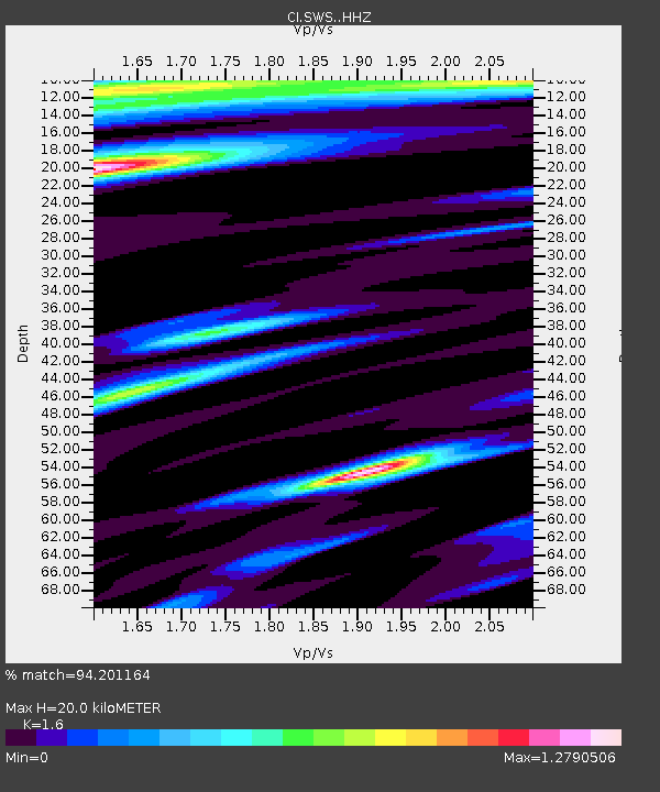
| Estimated Moho Depth: |
20.0 km |
| Estimated Crust Vp/Vs: |
1.60 |
| Assumed Crust Vp: |
6.155 km/s |
| Estimated Crust Vs: |
3.847 km/s |
| Estimated Crust Poisson's Ratio: |
0.18 |
|
| Radial Match: |
94.201164 % |
| Radial Bump: |
400 |
| Transverse Match: |
89.39186 % |
| Transverse Bump: |
400 |
| SOD ConfigId: |
31937991 |
| Insert Time: |
2023-09-22 22:25:42.770 +0000 |
| GWidth: |
2.5 |
| Max Bumps: |
400 |
| Tol: |
0.001 |
|

Signal To Noise
| Channel | StoN | STA | LTA |
| CI:SWS: :HHZ:20230908T22:23:10.917981Z | 0.7234828 | 2.0097296E-7 | 2.777854E-7 |
| CI:SWS: :HHN:20230908T22:23:10.917981Z | 0.5892181 | 2.0127015E-7 | 3.4158856E-7 |
| CI:SWS: :HHE:20230908T22:23:10.917981Z | 2.8335032 | 7.5567294E-7 | 2.6669213E-7 |
| Arrivals |
| Ps | 2.0 SECOND |
| PpPs | 8.3 SECOND |
| PsPs/PpSs | 10 SECOND |


