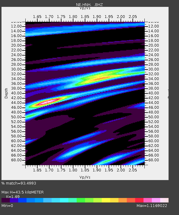
HNH Hanover, NH - Earthquake Result Viewer

Earthquake location: Fox Islands, Aleutian Islands
Earthquake latitude/longitude: 52.9/-169.8
Earthquake time(UTC): 2010/07/18 (199) 05:56:44 GMT
Earthquake Depth: 14 km
Earthquake Magnitude: 6.3 MB, 6.7 MS, 6.6 MW, 6.6 MW
Earthquake Catalog/Contributor: WHDF/NEIC
Network: NE New England Seismic Network
Station: HNH Hanover, NH
Lat/Lon: 43.71 N/72.29 W
Elevation: 180 m
Distance: 60.7 deg
Az: 55.547 deg
Baz: 316.436 deg
Ray Param: 0.06136768
Estimated Moho Depth: 43.5 km
Estimated Crust Vp/Vs: 1.69
Assumed Crust Vp: 6.419 km/s
Estimated Crust Vs: 3.798 km/s
Estimated Crust Poisson's Ratio: 0.23
Radial Match: 93.4993 %
Radial Bump: 400
Transverse Match: 84.67751 %
Transverse Bump: 400
SOD ConfigId: 319893
Insert Time: 2011-01-05 05:37:42.204 +0000
GWidth: 2.5
Max Bumps: 400
Tol: 0.001

Signal To Noise

ChannelStoNSTALTA
NE:HNH: :BHZ:20100718T06:06:24.44001Z5.39004141.0186208E-61.88982E-7
NE:HNH: :BHN:20100718T06:06:24.44001Z2.58181953.8988478E-71.5101163E-7
NE:HNH: :BHE:20100718T06:06:24.44001Z3.0144664.9719944E-71.6493782E-7
Arrivals
Ps4.9 SECOND
PpPs17 SECOND
PsPs/PpSs22 SECOND