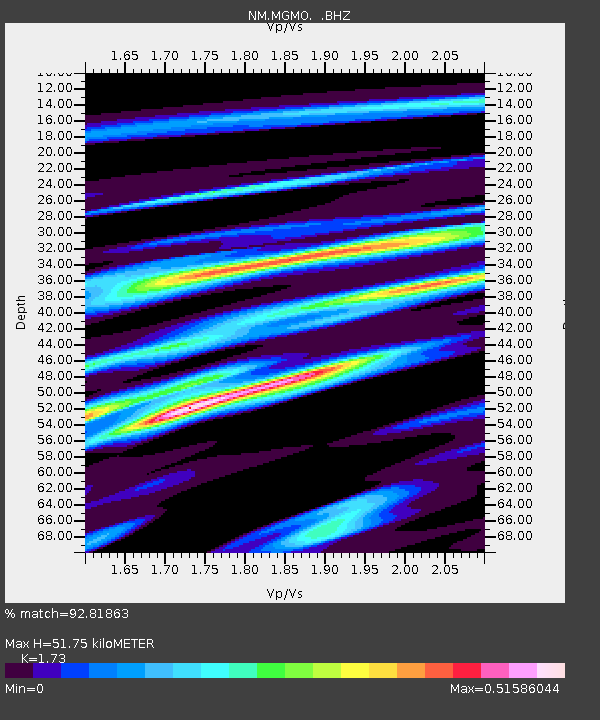
MGMO Mountain Grove, MO - Earthquake Result Viewer

Earthquake location: Fox Islands, Aleutian Islands
Earthquake latitude/longitude: 52.9/-169.8
Earthquake time(UTC): 2010/07/18 (199) 05:56:44 GMT
Earthquake Depth: 14 km
Earthquake Magnitude: 6.3 MB, 6.7 MS, 6.6 MW, 6.6 MW
Earthquake Catalog/Contributor: WHDF/NEIC
Network: NM Cooperative New Madrid Seismic Network
Station: MGMO Mountain Grove, MO
Lat/Lon: 37.15 N/92.27 W
Elevation: 453 m
Distance: 54.4 deg
Az: 73.723 deg
Baz: 313.262 deg
Ray Param: 0.06547827
Estimated Moho Depth: 51.75 km
Estimated Crust Vp/Vs: 1.73
Assumed Crust Vp: 6.53 km/s
Estimated Crust Vs: 3.775 km/s
Estimated Crust Poisson's Ratio: 0.25
Radial Match: 92.81863 %
Radial Bump: 377
Transverse Match: 80.60642 %
Transverse Bump: 400
SOD ConfigId: 319893
Insert Time: 2011-01-05 05:38:52.949 +0000
GWidth: 2.5
Max Bumps: 400
Tol: 0.001

Signal To Noise

ChannelStoNSTALTA
NM:MGMO: :BHZ:20100718T06:05:40.145027Z9.8594762.4032252E-62.4374776E-7
NM:MGMO: :BHN:20100718T06:05:40.145027Z9.6090419.940042E-71.0344467E-7
NM:MGMO: :BHE:20100718T06:05:40.145027Z5.71615657.782534E-71.3614978E-7
Arrivals
Ps6.1 SECOND
PpPs20 SECOND
PsPs/PpSs27 SECOND