You are here: Home > Network List > TA - USArray Transportable Network (new EarthScope stations) Stations List
> Station 109C Camp Elliot, Mirimar, CA, USA > Earthquake Result Viewer
109C Camp Elliot, Mirimar, CA, USA - Earthquake Result Viewer

| Earthquake location: |
Fox Islands, Aleutian Islands |
| Earthquake latitude/longitude: |
52.9/-169.8 |
| Earthquake time(UTC): |
2010/07/18 (199) 05:56:44 GMT |
| Earthquake Depth: |
14 km |
| Earthquake Magnitude: |
6.3 MB, 6.7 MS, 6.6 MW, 6.6 MW |
| Earthquake Catalog/Contributor: |
WHDF/NEIC |
|
| Network: |
TA USArray Transportable Network (new EarthScope stations) |
| Station: |
109C Camp Elliot, Mirimar, CA, USA |
| Lat/Lon: |
32.89 N/117.11 W |
| Elevation: |
150 m |
|
| Distance: |
42.4 deg |
| Az: |
96.607 deg |
| Baz: |
314.308 deg |
| Ray Param: |
0.07319336 |
| Estimated Moho Depth: |
16.25 km |
| Estimated Crust Vp/Vs: |
2.09 |
| Assumed Crust Vp: |
6.264 km/s |
| Estimated Crust Vs: |
2.997 km/s |
| Estimated Crust Poisson's Ratio: |
0.35 |
|
| Radial Match: |
94.79338 % |
| Radial Bump: |
312 |
| Transverse Match: |
89.09921 % |
| Transverse Bump: |
400 |
| SOD ConfigId: |
319893 |
| Insert Time: |
2011-01-05 05:40:48.257 +0000 |
| GWidth: |
2.5 |
| Max Bumps: |
400 |
| Tol: |
0.001 |
|
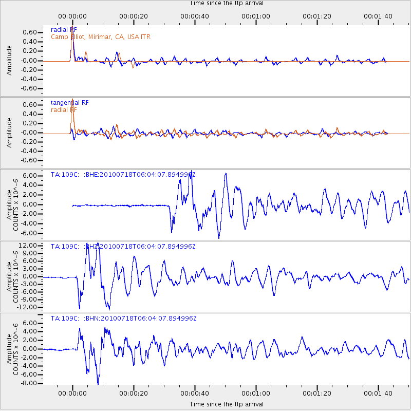
Signal To Noise
| Channel | StoN | STA | LTA |
| TA:109C: :BHZ:20100718T06:04:07.894996Z | 48.897755 | 5.6558224E-6 | 1.156663E-7 |
| TA:109C: :BHN:20100718T06:04:07.894996Z | 19.414877 | 2.3272794E-6 | 1.1987092E-7 |
| TA:109C: :BHE:20100718T06:04:07.894996Z | 30.864607 | 2.2714466E-6 | 7.3593895E-8 |
| Arrivals |
| Ps | 3.0 SECOND |
| PpPs | 7.6 SECOND |
| PsPs/PpSs | 11 SECOND |


