Q24A Divide, CO, USA - Earthquake Result Viewer
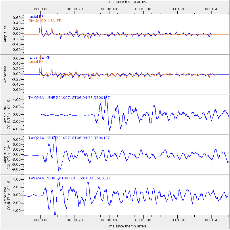
Earthquake location: Fox Islands, Aleutian Islands
Earthquake latitude/longitude: 52.9/-169.8
Earthquake time(UTC): 2010/07/18 (199) 05:56:44 GMT
Earthquake Depth: 14 km
Earthquake Magnitude: 6.3 MB, 6.7 MS, 6.6 MW, 6.6 MW
Earthquake Catalog/Contributor: WHDF/NEIC
Network: TA USArray Transportable Network (new EarthScope stations)
Station: Q24A Divide, CO, USA
Lat/Lon: 38.96 N/105.15 W
Elevation: 2775 m
Distance: 45.6 deg
Az: 80.765 deg
Baz: 309.879 deg
Ray Param: 0.071182124
Estimated Moho Depth: 36.0 km
Estimated Crust Vp/Vs: 2.06
Assumed Crust Vp: 6.159 km/s
Estimated Crust Vs: 2.986 km/s
Estimated Crust Poisson's Ratio: 0.35
Radial Match: 92.425766 %
Radial Bump: 366
Transverse Match: 75.108406 %
Transverse Bump: 400
SOD ConfigId: 319893
Insert Time: 2011-01-05 05:42:03.369 +0000
GWidth: 2.5
Max Bumps: 400
Tol: 0.001

Signal To Noise

ChannelStoNSTALTA
TA:Q24A: :BHZ:20100718T06:04:33.350013Z20.8212852.660363E-61.2777132E-7
TA:Q24A: :BHN:20100718T06:04:33.350013Z11.9866111.283192E-61.070521E-7
TA:Q24A: :BHE:20100718T06:04:33.350013Z10.7065211.1687906E-61.09166244E-7
Arrivals
Ps6.5 SECOND
PpPs17 SECOND
PsPs/PpSs24 SECOND