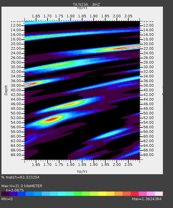
N23A Red Feather Lakes, CO, USA - Earthquake Result Viewer
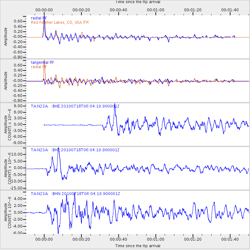
Earthquake location: Fox Islands, Aleutian Islands
Earthquake latitude/longitude: 52.9/-169.8
Earthquake time(UTC): 2010/07/18 (199) 05:56:44 GMT
Earthquake Depth: 14 km
Earthquake Magnitude: 6.3 MB, 6.7 MS, 6.6 MW, 6.6 MW
Earthquake Catalog/Contributor: WHDF/NEIC
Network: TA USArray Transportable Network (new EarthScope stations)
Station: N23A Red Feather Lakes, CO, USA
Lat/Lon: 40.89 N/105.94 W
Elevation: 2458 m
Distance: 43.9 deg
Az: 79.185 deg
Baz: 308.248 deg
Ray Param: 0.07225542
Estimated Moho Depth: 21.0 km
Estimated Crust Vp/Vs: 2.09
Assumed Crust Vp: 6.306 km/s
Estimated Crust Vs: 3.021 km/s
Estimated Crust Poisson's Ratio: 0.35
Radial Match: 93.323204 %
Radial Bump: 400
Transverse Match: 77.633 %
Transverse Bump: 400
SOD ConfigId: 319893
Insert Time: 2011-01-05 05:42:11.219 +0000
GWidth: 2.5
Max Bumps: 400
Tol: 0.001

Signal To Noise

ChannelStoNSTALTA
TA:N23A: :BHZ:20100718T06:04:19.900001Z33.6785553.2440257E-69.6323184E-8
TA:N23A: :BHN:20100718T06:04:19.900001Z17.3152661.3150553E-67.5947746E-8
TA:N23A: :BHE:20100718T06:04:19.900001Z17.2219281.6021245E-69.302817E-8
Arrivals
Ps3.8 SECOND
PpPs9.7 SECOND
PsPs/PpSs14 SECOND