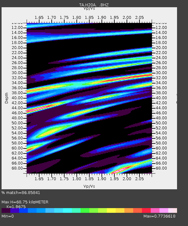
H20A Greybull, WY, USA - Earthquake Result Viewer
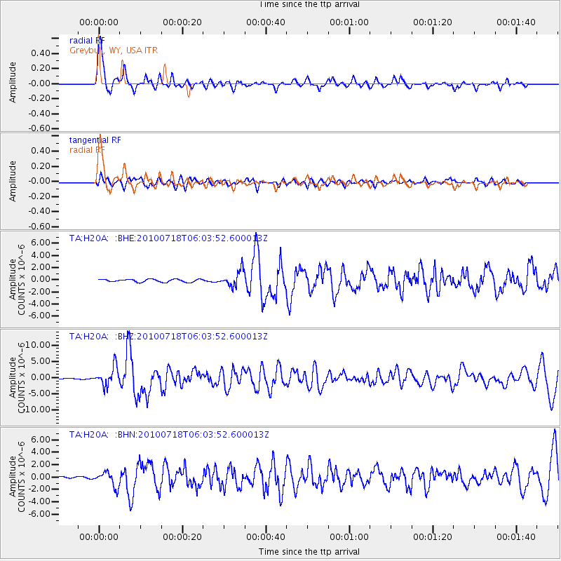
Earthquake location: Fox Islands, Aleutian Islands
Earthquake latitude/longitude: 52.9/-169.8
Earthquake time(UTC): 2010/07/18 (199) 05:56:44 GMT
Earthquake Depth: 14 km
Earthquake Magnitude: 6.3 MB, 6.7 MS, 6.6 MW, 6.6 MW
Earthquake Catalog/Contributor: WHDF/NEIC
Network: TA USArray Transportable Network (new EarthScope stations)
Station: H20A Greybull, WY, USA
Lat/Lon: 44.49 N/108.00 W
Elevation: 1236 m
Distance: 40.5 deg
Az: 76.228 deg
Baz: 304.667 deg
Ray Param: 0.07434131
Estimated Moho Depth: 68.75 km
Estimated Crust Vp/Vs: 1.97
Assumed Crust Vp: 6.178 km/s
Estimated Crust Vs: 3.14 km/s
Estimated Crust Poisson's Ratio: 0.33
Radial Match: 86.85841 %
Radial Bump: 400
Transverse Match: 63.654797 %
Transverse Bump: 400
SOD ConfigId: 319893
Insert Time: 2011-01-05 05:42:27.436 +0000
GWidth: 2.5
Max Bumps: 400
Tol: 0.001

Signal To Noise

ChannelStoNSTALTA
TA:H20A: :BHZ:20100718T06:03:52.600013Z25.0761013.0039334E-61.1979269E-7
TA:H20A: :BHN:20100718T06:03:52.600013Z9.1430271.2156931E-61.3296398E-7
TA:H20A: :BHE:20100718T06:03:52.600013Z5.82428031.3355598E-62.2930898E-7
Arrivals
Ps11 SECOND
PpPs31 SECOND
PsPs/PpSs43 SECOND