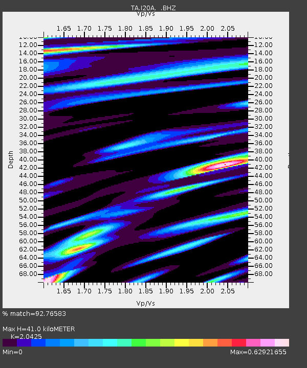
I20A Worland, WY, USA - Earthquake Result Viewer
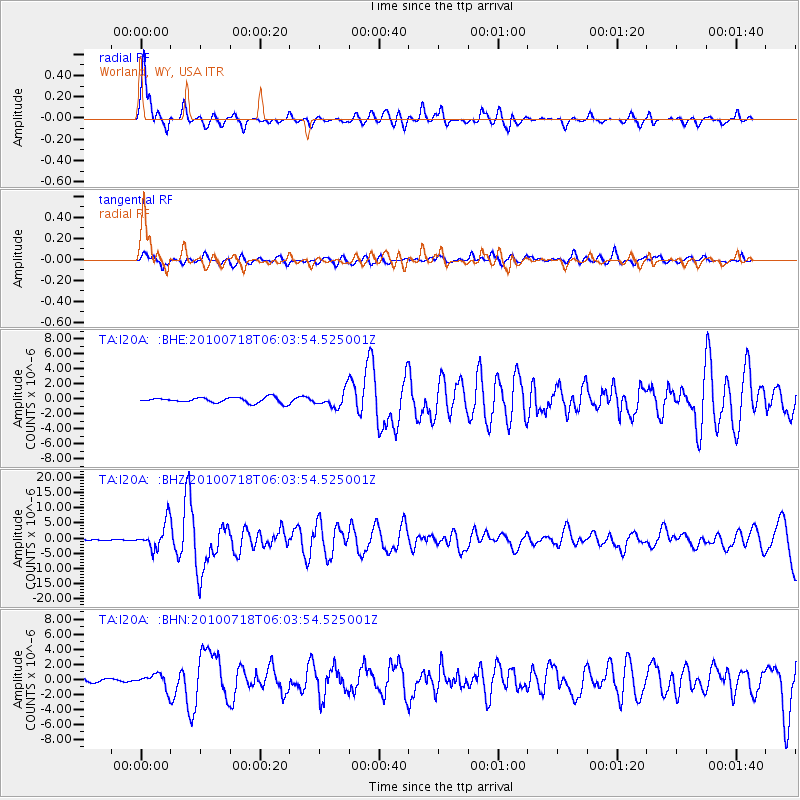
Earthquake location: Fox Islands, Aleutian Islands
Earthquake latitude/longitude: 52.9/-169.8
Earthquake time(UTC): 2010/07/18 (199) 05:56:44 GMT
Earthquake Depth: 14 km
Earthquake Magnitude: 6.3 MB, 6.7 MS, 6.6 MW, 6.6 MW
Earthquake Catalog/Contributor: WHDF/NEIC
Network: TA USArray Transportable Network (new EarthScope stations)
Station: I20A Worland, WY, USA
Lat/Lon: 43.95 N/108.13 W
Elevation: 1342 m
Distance: 40.8 deg
Az: 76.986 deg
Baz: 305.152 deg
Ray Param: 0.0742035
Estimated Moho Depth: 41.0 km
Estimated Crust Vp/Vs: 2.04
Assumed Crust Vp: 6.161 km/s
Estimated Crust Vs: 3.016 km/s
Estimated Crust Poisson's Ratio: 0.34
Radial Match: 92.76583 %
Radial Bump: 400
Transverse Match: 76.82816 %
Transverse Bump: 400
SOD ConfigId: 319893
Insert Time: 2011-01-05 05:42:36.925 +0000
GWidth: 2.5
Max Bumps: 400
Tol: 0.001

Signal To Noise

ChannelStoNSTALTA
TA:I20A: :BHZ:20100718T06:03:54.525001Z29.4328614.3372493E-61.4736078E-7
TA:I20A: :BHN:20100718T06:03:54.525001Z3.93609719.680004E-72.45929E-7
TA:I20A: :BHE:20100718T06:03:54.525001Z3.00310781.0762259E-63.5837073E-7
Arrivals
Ps7.3 SECOND
PpPs19 SECOND
PsPs/PpSs26 SECOND